TENERIFE – Canary Islands
You know, the mountain does not come to you, it is you who must go to the mountain. And here you’ll find it, the magnificent “El Teide”… 😉
For walkers, the northern parts of Tenerife will have what is most interesting, even if the weather might be a little cooler and more unstable here than in the more typical tourist areas in the south. Rain and fog is not uncommon. Luckily the fairly big but still very nice town of Puerto de la Cruz is beautifully situated just on the north coast. Its more genuine atmosphere and relaxed ways also makes it a favorite among many tourists.
It also has endless possibilities of reasonable eating. But you should preferably stay away of Plaza Charco and the touristy pedestrian street Calle Viejo. Instead move one more block towards the sea, and walk as far into the old town as possible along this street, the Calle de San Felipe, to find the Casa Antigua. The next street towards the sea also have some hidden gems. Then work, or more or less literally, eat your way back towards Plaza Charco during your stay. The last restaurant in that direction is Regulo. It is supposedly very good, but I have never gotten this far back myself…
The “capital” Santa Cruz might also be used to have easier access to the Anaga peninsula.
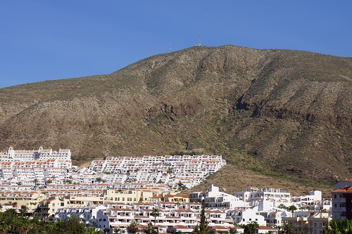
There are nice places in the south of the island as well, e.g Los Cristianos is surprisingly cosy. Superb tapas at “Mokelino” (a new and very modern place, at C.C. Ledesbell, Paseo Marítimo 17) and “El Burgado” (a very traditional place, at Calle Juan XXIII 2). Even in Playa de Las Americas I did discover some superb dining. “El Faro” (Avenida Las Americas S/N Parque Santiago V) is a very good pick. I had one of my best meals ever in the entire Canaries at that place. Try e.g. their “Fried Camenbert with Mulberry Sauce” as a starter, it is incredible…
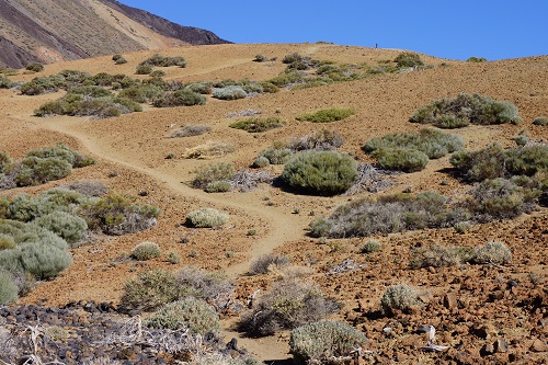
Four areas can be singled out as essential to a walker. These are: The Orotava valley, Las Cañadas (with El Teide), the Anaga range, and the Teno range. You can find my suggestions below, but the possibilities are nearly endless.
Selected walks: For walks on Tenerife take a look in Noel Rochford’s books “Landscapes of Tenerife” (referred to below as “/Rochford1/”, walk numbers etc. are taken from the 8th edition unless otherwise noted) and “Landscapes of La Gomera and Southern Tenerife” (referred to below as “/Rochford2/”, walk numbers etc. are taken from the 6th edition). You should also check out “Tenerife Hiking Map” and “Walk! Tenerife” (referred to below as /Brawn/) by Discovery Walking Guides. There is also “Walking in the Canaries Volume 1” by Paddy Dillon and “Tenerife” by Klaus and Annette Wolfsperger (referred to below as /Wolfsperger/). Tenerife is even mentioned in Lonely Planet’s “Walking in Spain”. I have done walks 1-6 below based in Puerto de la Cruz, walks 7-9 based in Santa Cruz, walks 10-15 from the Parador de Las Cañadas del Teide and walks 16-17 based in Los Cristianos.
UPDATE: As of 2018 /Rochford2/ is up to the 8th edition. Any comments I have will be added after each walk where this book was used.
•1 PUERTO DE LA CRUZ – CAFÉ VISTA PARAÍSO – PUERTO DE LA CRUZ (my total time 4h28, includes short stops for drinking and photography; +-564m, 4 laps): This is /Rochford1/‘s walk 1, but adds the walk back to the Puerto. This walk is easy to find and follow and the instructions in the book are more than sufficient. Do bring good boots for the climb to the Café. I would say a walking stick is needed if you are going to follow my example and descend back the same way.
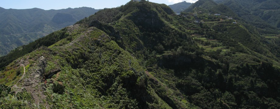
•2 LAS CARBONERAS – TABORNO – ROQUE DE TABORNO – TABORNO – CASA CARLOS – CRUZ DEL CARMEN – LAS MERCEDES (my total time 5h47, includes short stops for drinking and photography, as well as ONE HOUR LUNCH at Casa Carlos; +828m -747m, 4 laps): This is /Rochford1/‘s walk 24, but adds the walk from Casa Carlos to Las Mercedes, via Cruz del Carmen. The main parts of the walk are also walk 44 followed by walk 43 (in reverse) from /Brawn/. The last part of the walk, from Cruz del Carmen, is part of walk 41 in /Brawn/. If you are a fairly experienced walker you should have little problems doing the entire walk.
The instructions in /Rochford1/ should be more than sufficient for the walk from Las Carboneras via Taborno and Roque Taborno to Casa Carlos, but do follow them CAREFULLY.
After lunch I continued by road to Cruz del Carmen. The road is mostly wide and with little traffic so it is quite safe. Just take some care at a couple of blind corners.
At Cruz del Carmen go left into the parking area and find the marked footpath to Las Mercedes. The path is for the most part wide, but it can be incredibly slippery after wet weather! At unmarked forks the correct way is invariably down and to the right. Cross the main road, and at the Las Mercedes Area Recreativa picnic area follow a sign slightly downwards and to the right, across the creek. This path will deposit you after 10 mins or so back onto the main road. Just walk down to the nearest bus stop. From Las Mercedes there are many buses towards La Laguna, most notably lines 70/71.
•3 EL PORTILLO – PALO BLANCO (- REALEJO ALTO) (my total time 4h32, includes short stops for drinking and photography; +151m -1464m, 1 lap): This is /Rochford1/‘s walk 13. I have no notes that matches the route in the current edition of the book as it has changed quite a bit lately, partly caused by forest fire. Regardless, the route should be pretty clear.
An added half hour to the time above takes you further down to Realejo Alto, where the are more buses. Most notably lines 390/391 directly back to Puerto. Both the text and the map in the book outlines how to get there, and you should have no problems finding your way.
•4 ICOD EL ALTO – LA GUANCHA (my total time 5h58, includes short stops for drinking and photography; +813m -871m, 1 lap): This is /Rochford1/‘s walk 15. No noteworthy problems en route.
As you can see from my timings above, the book exaggerates the length of this walk a bit.
•5 LA CALDERA – LOMO DE LOS BREZOS – AGUAMANSA (my total time 4h20, includes short stops for drinking and photography; +631m -775m, 2 laps): This is /Rochford1/‘s walk 6, or a variant of walk 5 in /Brawn/ in reverse.
The walk will take you above Los Organos and you will have exhilarating views down the valley (and into the local barrancos…), but there is really no need to worry. The path is rather good, and at the most vertiginous stretch a handrail is securely fastened to the cliff wall.
•6 LA MONTAÑETA DEL PALMAR – TENO ALTO – TENO BAJA – BUENAVISTA (duration 4h45mins): This is walk 20 in /Rochford1/. To ask the bus driver for La Montañeta (or even “el camino para Teno Alto”) may not be a great success. Instead buy your ticket to El Palmar and walk the few meters up to the clearly visible sign for Teno Alto.
The only real hazard on this walk may be the road back to Buenavista. The road itself is wide, mostly in excellent condition, and traffic is low. But beware that in windy and/or rainy conditions the possibility of falling rocks and landslides will make this stretch risky! AND YOU MUST REMEMBER TO BRING A TORCH FOR THE TUNNEL.
OBS: I did this walk last in 1999!
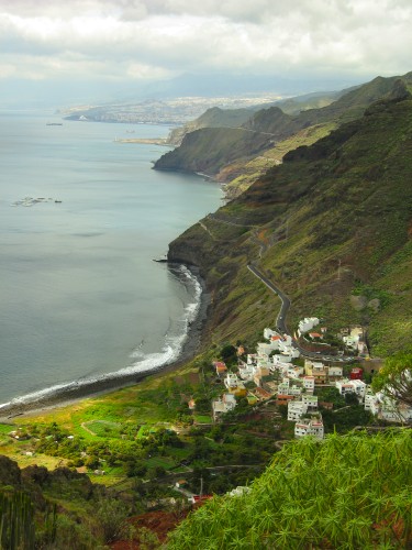
•7 CRUZ DEL CARMEN – PICO DEL INGLÉS – SANTA CRUZ (my total time 4h33, includes short stops for drinking and photography; +100m -1026, 1 lap): This is /Rochford1/‘s walk 26, just starting at Cruz del Carmen. I added the initial road walk because the walk looked rather short. This was before I realized that I could actually walk all the way back to my hotel without problems. So my timing goes all that way.
No problems to note with this walk.
•8 IGUESTE DE SAN ANDRÉS – SEMÁFORO (+RETURN) (my total time 2h57, includes short stops for drinking, lots of time for photography, and a half hour break at the Semáforo before returning; +-457m, 2 laps): This is /Rochford1/‘s walk 30 Short Walk 1.
No problems to note with this walk.
•9 BARRANCO DEL RÍO (my total time 2h27, includes short stops for drinking and photography; +-275m, 2 laps): This walk is part of /Rochford1/‘s walk 22 Alternative Walk, going both up and returning back down the barranco itself.
No problems to note with this walk, just follow the barranco up to where it meets the canal, then return back down. Be aware that the MAIN walk 22 is for suicide candidates only. The edge of the canal is only 15cms wide and there is rapid water inside it… Imagine balancing on that edge for a couple of hundred meters up the hillside!
•10 PARADOR DE LAS CAÑADAS – GUAJARA – PARADOR DE LAS CAÑADAS (my total time 4h44; 888a 881d; net walking time 3h35): This is walk 36 in /Brawn/ (See also walk 63 in /Wolfsperger/ and walk 12 in /Rochford1/). Be careful using guidebooks luring you onto a difficult and dangerous path. Use the safe route suggested by /Brawn/. Also mind that the top of Guajara, at 2715m, can be extremely cold and windy. Come prepared.
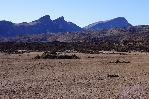
•11 PARADOR DE LAS CAÑADAS – EL PORTILLO (my total time 3h20; 325a 411d; net walking time 3h01): This is walk 61 in /Wolfsperger/. Same as walk 9 in /Rochford1/ or walk 37 in /Brawn/, but in reverse. A tremendous walk in an at best fantastic lunar landscape, with Teide looming over you. The walk is very easy to find and follow. But do bring warm clothes!
•12 PARADOR DE LAS CAÑADAS – MONTAÑA MAJÚA – PARADOR DE LAS CAÑADAS (my total time 3h08; 438a 421d; net walking time 2h37): This is walk 30 in /Brawn/. Very easy and on good surfaces, more like a long stroll. But surprisingly interesting.
•13 EL PORTILLO – ARENAS NEGRAS – EL PORTILLO (my total time 2h07; 304a 292d; net walking time 1h42): This is walk 31 in /Brawn/. A wonderful easy walk with immense views. Some modicum of care has to be taken on the decent.
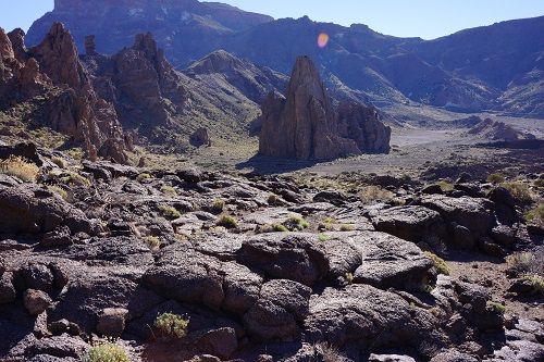
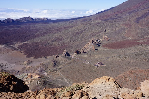
•14 MIRADOR DE LA RULETA – ROQUES DE GRACÍA – MIRADOR LLANO DE UCANCA – PARADOR DE LAS CAÑADAS (my total time 2h03; 248a 236d; net walking time 1h39): This is the extended version of walk 62 in /Wolfsperger/. For the last part I extended it further by following No. 26 trail all the way to the main road. I believe this is the way to go, you are not supposed to leave the marked trails in this area. This adds a bit of road walking, but the traffic is not horrible and the road is wide. If you want to line up with the right-hand side of the Cathedral and the the No. 26 trail (and if you feel adventurous), you can follow path fragments and the occasional cairn on the right-hand side of the lava field on your decent. This is where the official No. 3 trail crosses to the left side of the lava field (see my next walk, and also the picture above). You will be descending towards a huge cairn (and a path) down on the plain.
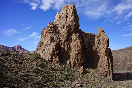
•15 MIRADOR DE LA RULETA – ROQUES DE GRACÍA – LA CATEDRAL – MIRADOR DE LA RULETA (my total time 1h28; 206a 205d; net walking time 1h09): This is walk 11 i /Rochford1/ (or 33 in /Brawn/, or the plain walk 62 in /Wolfsperger/. For a possible extension of this rather short walk see the walk above. Note that you should be following the official No. 3 trail all the way! The only thing a guide book needs to mention about this walk is that you will have to cross to the left side of the lava field on your decent. This is not at all clear and the entire area is covered with cairns, leaving you with a big question mark above your head. There are no No. 3 trail marks either here, not until you are almost down to the plain. Only /Brawn/ manages to mention this. One can really start to question other authors at this point, and why they are writing “guide” books in the first place.
•16 MOUNT GUAZA (my total time 3h26; 591a 590d; net walking time 2h56): This is /Rochford2/’s walk 1. For a simpler and shorter option see /Brawn/’s walk 9 or just follow your own footsteps back from the mountain. My timings start and end at the seaside promenade near my hotel (The H10 Big Sur).
No problems initially on this walk, but the route back goes wrong in the end. Where /Rochford2/ tell you to go right (“next T-Junction, two minutes later”), you miss the gravel cone and the coastal path marked with white paint blobs (and the occasional green), coming onto a more inland route marked in blue. Where this ends you can still get back to the coastal path by going left and over a small hillock.
UPDATE: The text in the 8th edition of /Rochford2/ is virtually unchanged from the 6th edition, and is still just as confusing to me. Just keep ahead and/or left(-ish) until you are at the coastal path itself, this is where you eventually turn right.
•17 LOS CRISTIANOS – PALM MAR – FARO DE RASCA – LOS CRISTIANOS (my total time 4h28; 556a 549d; net walking time 3h45): This is (part of) /Wolfsperger/’s walk 37, but returning from Faro de Rasca using the alternative return to Los Cristianos taken from walk 8 in /Brawn/. My timings start and end at the seaside promenade near my hotel (The H10 Big Sur).
Be aware that the descent to Palm Mar is SCARY. Also be sure that on the return you do NOT walk that horribly trafficked road from the entrance to Palm Mar. Just cross it (carefully and using the pedestrian crossing) and pick up a path over the fields on the other side.
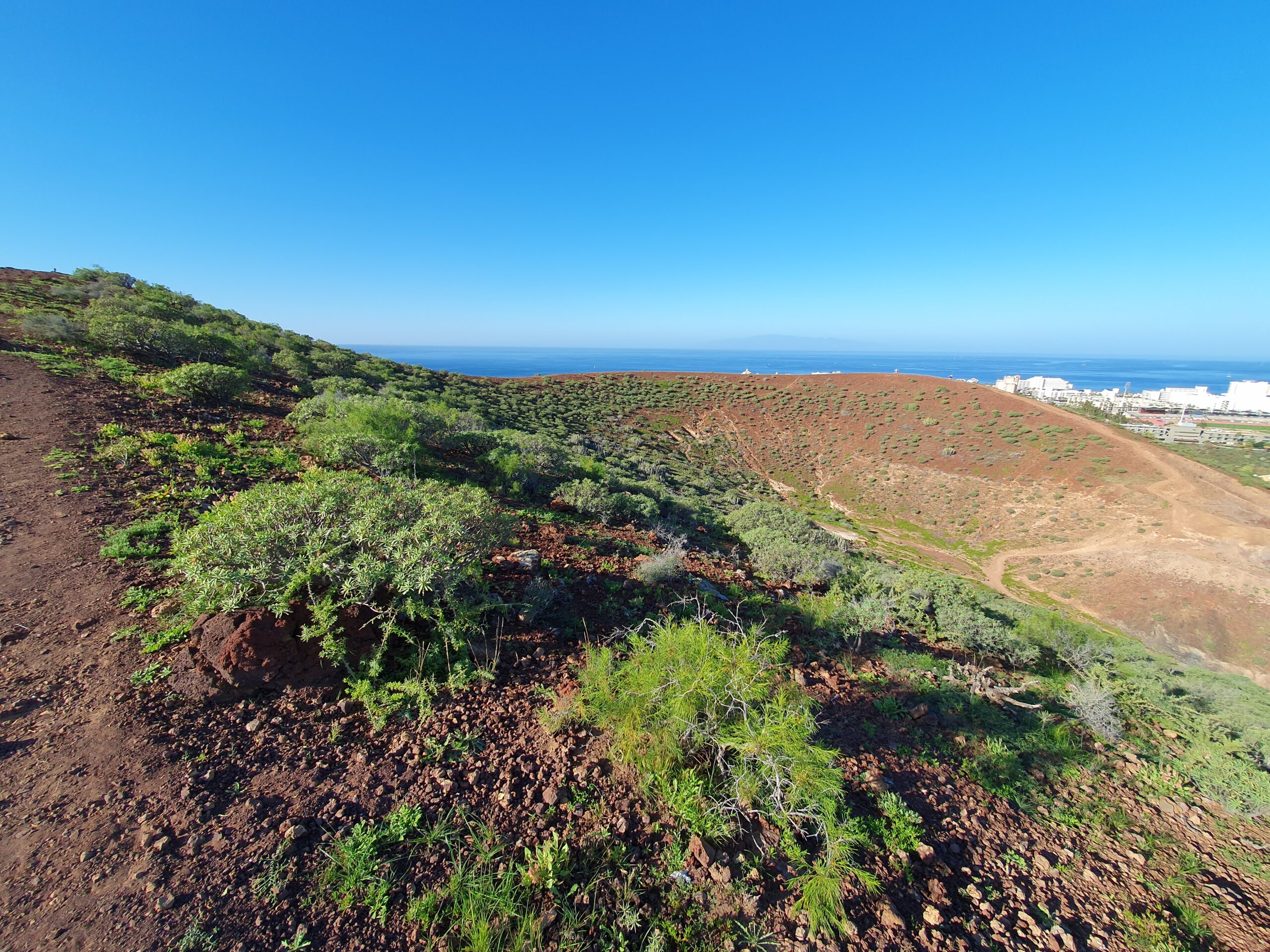
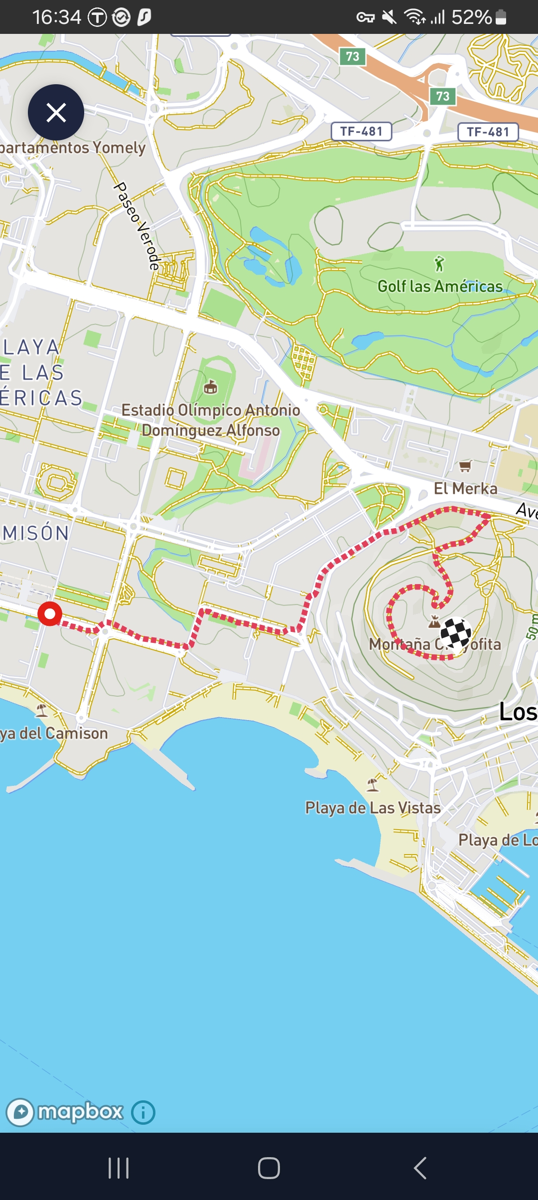 •18 PLAYA DE LAS AMERICAS (or LOS CRISTIANOS) – MONTAÑA CHAYOFITA (0:34; 3054 steps; 2.1km; alt. gain 99m; alt. loss 3m): Strolling to the top of this small mountain is readily available from anywhere in this area, I just timed it from my hotel in Playa de Las Americas (The Cleopatra Palace). The paths up the mountain are from the north side. A short walk, but note that my timings are just for one way. The mountain itself can be traversed in a circular fashion, I chose counter clockwise.
• Good starting points: • Puerto de la Cruz – from here buses will take you to most of the northern coast area and also into the Orotava valley and to Las Cañadas • Santa Cruz – for easiest access to the northernmost part of the island • Los Cristianos – for the easiest access to the southernmost part
• How to get there: • By air • Some ferries from other Canary islands do exist
• More info: • TITSA, bus schedules and info
This page was last modified at March 9, 2026.
©1997-2026