Ρόδος – Dodecanese
Sunny and hospitable Rhodes can almost be considered a whole year destination and is also good, because of its airport, as a springboard to other Dodecanese islands. Many will consider Rhodes just a “tourist” island (whatever that is) but it is so big that you should find something for your taste, regardless. The island is nicely green, especially in the south-west, and offers a good selection of walks and strolls.
The island is just terrific for sightseeing, and Rhodes Old Town offers great food if you know where to go. There are also horrible rip-offs. I can personally recommend “Yannis Home Cooking” (Platonos 41, just below Hotel Domus Rodos, the former Hotel Sydney). He has perhaps the best Moussaka I have ever tasted. A simple, inexpensive and genuinely Greek place. For meze “Ta Petaladika” (Menekleous 8) is absolutely awesome. Just out of old town, “Ουτε Λεπι” (Averof 50) has very good seafood pastas. I am also happy to announce that the old classic Kostas is back in good shape.
There are quite a few very interesting hotels in the Old Town. A real treat is the hidden away Camelot Hotel at Themistokleous 18. When I stayed here the first time the hotel had just three rooms, now they have expanded slightly and have a brand new reception area also. Many thanks to Nina for letting me stay in her little castle! Always #1 in my heart, so regardless of other offers, when I’m in town I will of course stay nowhere else.
In Monolithos a wonderful hotel with an extremely helpful owner is the Thomas Hotel. You cannot stay in Monolithos without visiting the Old Monolithos taverna, but there is a new place called Limeri up on the main road now and it is absolutely superb. Christos Corner is also good.
In Apolakkia the Amalia hotel and taverna is great both for staying and eating.
In Kattavia the Prasonisi Club is a very helpful hotel with good breakfasts. Louis and Penelope became my two favorite places for eating.
Selected walks: For walks on the island, see “Walk & Eat Rhodes” by Brian and Eileen Anderson (referred to below as “/Anderson/”) and “Rhodes Karpathos Kos Southern Dodecanese” by Dieter Graf (referred to below as “/Graf/”). Some now outdated books are “Trekking in Greece” by Marc Dubin (out of print) and “Landscapes of Rhodes” by Noel Rochford (also out of print, but referred to below as “/Rochford/”, actually the 2nd edition). There was also a booklet by Lance Chilton called “Walks in the Lindos & Pefkos Area”, but even this is out of print. I first list a number of possible “city walks” that can be done if you have not previously visited. Very good for getting to know the town and getting your general orientation in place. Actually, they are so nice that at least the wall walks can be done with pleasure again and again.
I will also be referring to the 2018 Hiking and Walking in Greek islands – Rhodes by Sergio Mazitto as /Mazitto/. This a very detailed walking atlas of the island.
UPDATE: There is a newer (2011) edition of /Graf/. If not otherwise noted (by using the reference /Graf2/) I used the original 2005 edition. I have noted below for these walks if there are any significant differences. There is also a 2nd edition of /Anderson/, but I have not been able to get hold of a copy.
•1 RHODES OLD TOWN (my total time 1h37, this includes stops for photography as well as some refreshments at a suggested waterhole; +29m -28m; 0 laps): This is walk 1 in /Anderson/. Absolutely everyone should do this little walk to get to know the Old Town.
•2 OLD TOWN WALLS (my total time 1h06, this includes stops for photography; +16m -36m; 0 laps): This is walk 2 in /Anderson/. The book has a little misleading information here. At best the town walls are only open for a few hours two days a week, currently Tuesday and Saturday, according to official information. This is fairly essential if you want to do this walk! A new experience for me to walk on top of these walls, and one that has my warmest recommendations if you are here on a matching day (but do see also walk 3 below).
•3 MEDIEVAL MOAT (my total time 0h51, this includes stops for photography; +-25m; 0 laps): See also walk 2 above, but walking inside the moat at least for me is the most spectacular experience you can have with these walls. If you have to choose, do this one. Start at either end, from Mandraki harbour (enter through something that looks like just a gate to a couple of tavernas) and walk counter-clockwise or close to Karetou gate and walk clockwise. You can also use a number of entries/exits directly from/to Old Town if you want.
•4 MONTE SMITH (my total time 1h13, this includes stops for photography as well as the minimum of necessary sightseeing; +-55m; 1 lap): Another small stroll to do some essential sightseeing. I started just outside the Old Town, at d’Amboise gate and then walked basically south-west to find this hill. You can follow the street signs to the “Acropolis” if you want. Also equip yourself with the usual Rodos road map and you cannot go wrong. As you can see from the height difference, the “mountain” is not of the huge kind…
•5 KÁLATHOS – LÍNDOS (my total time 2h30, this includes stops for photography and a small picnic; +277m -245m; 1 lap): This is basically walk 11 in the 1st edition, walk 9 in the 2nd edition of /Graf/, I just strolled the extra few hundred meters from the bus stop in Kálathos. Similar walks are walk 8 in /Anderson/ and walk 13 in /Rochford/.
A very stony but still nice walk. Try to follow the cairns and red paint blobs that mark almost all of the walk as much as possible, and do not stray. That would be fairly uncomfortable in this terrain.
Note that I have only used the initial approach from /Rochford/ and /Anderson/. This is now in the 2nd edition of /Graf/ part of a new alternative circular route. I feel there is little reason to leave the road before you find the start of the track you are actually supposted to follow, that could only lead to unnecessary complications. This way, and before you encounter the first cairn, you just move upstream (by the final creek you meet) on a track until you get to where the path itself forks off. This approach cannot really go wrong in any case, as you will have a clear view of where you are going at all points.
Líndos is pleasant for refreshments before you stroll up the road to the bus stop. Notice the new ticket kiosk just across the main road.
•6 ARCHÁNGELOS – STEGNÁ – TSAMBÍKA – MONÍ TSAMBÍKA (my total time 3h46, this includes stops for photography and refreshments, add your time for swims; +490m -577m; 3 laps): This is a fantastic walk constructed from three separate parts.
First part (Archángelos – Stegná) is taken from walk 5 in /Anderson/. When the book tells you to “stay ahead” (3min) actually fork right away from the main Stegná road. Take care so you find the marked and cairned path down to Stegná. This is not mentioned in any of the books, but this path actually forks after a while. Do take care to follow the lower route down into the valley. Cairns (at least initially) mark both paths, only the lower one has additional paint blobs.
Second part (Stegná – Tsambíka) is taken from walk 10 in /Rochford/, but what you do here is to connect with walk 13 (11 in the 2nd edition) in /Graf/ by using a signposted path (later track) towards Tsambíka. Near the northern end of Stegná, where the street forks into one gravel road in front of houses and one behind, a third option goes sharp left on a path through an open (hopefully) gate. Even if you cannot read the letters the sign for Tsambíka should be clearly visible a few meters ahead and to the left. The steep and very rough path goes up the incline. Soon it turns into a rough track. Keep moving ahead upwards until you meet the route followed in /Graf/ at the “olive garden”. Massive road building has more or less destroyed the access to the overgrown track you are supposed to follow from here. You might need to hunt carefully for it in the future. When the track ends hunt out for the continuing footpath slightly to the south (away from the beach). The path takes you to the (in-)famous sand slide.
The third part (Tsambíka – Moní Tsambíka) follows the fabulous route described in /Graf/ (still walk 13, or 11 if you have the 2nd edition). It is actually easier than it looks! After the cloister stroll down the road to the bus stop.
•7 ARCHÁNGELOS – STEGNÁ – HARÁKI ( – MÁSSARI ) (my total time 4h34, this includes stops for photography and refreshments, as well as a dip in the ocean; +412m -527m; 3 laps): This is basically walk 12 in the first edition, walk 10 in the 2nd edition of /Graf/. See also walk 12 in /Rochford/. A really great coastal walk.
As for walk 6 above take care so you find the marked and cairned path down to Stegná. This is not mentioned in any of the books, but this path actually forks after a while. Do take care to follow the lower route down into the valley. Cairns (at least initially) mark both paths, only the lower one has additional paint blobs.
To get some additional help with route finding from Stegná also refer to walk 5 in /Anderson/.
After that it is mostly a matter of finding and following waymarks. At the “old olive tree” (close to the 1.40 mark in /Graf/) take the track forking left for the beach. Take the track forking right to pick up continuing waymarks to the “little house”. The book is slightly wrong here.
In Haráki, if you are not here in high season when there are buses, you must walk across the dry river bed and turn right with the street afterwards. Then you can stroll up to the bus stop in Mássari. The bus shelter is immediately left when you reach the main road.
•8 PETALOÚDES (my total time 1h53, this includes a lot of stops for photography, or at least tentative photography of those bloody critters, as well as a short visit to the museum; +-178m; 1 lap): This is walk 3 in /Anderson/. A shorter variant of walk 10 below. Good draught beer can be had in the snack bar after your walk!
•9 KOLÍMBIA – EFTÁ PIGÍS – ARCHÁNGELOS (net walking time 1h46): This was walk 9 in /Rochford/. A very easy walk in all respects. A similar walk is walk 4 in /Anderson/. A longer walk has been added to the 2nd edition of /Graf/, as walk 12.
At Eftá Pigís, if you take the path back from the reservoir, you do not need to go back to the restaurant area, turn left on the road instead of crossing it. The path for Archángelos is just a minute away (on your left).
OBS: I did this walk last in 2002!
•10 PETALOÚDES – ÁGIOS SOULÁS – SORONÍ (net walking time 3h27): This was walk 8 in /Rochford/. Another easy walk that is easy to find and follow. A similar, but shorter walk is walk 3 in /Anderson/, see walk 8 above.
However, there more tracks to ignore than those mentioned in /Rochford/. And just out of the valley, when you reach the track, disregard the instructions in the book and follow instead the new marked path up to the Monastery, turning left just a few meters along the track. Shortly after the 1h58 point in /Rochford/ there is a new track down right. Just after the T-junction ignore a track down left. Be sure to spot (how can you miss it?) the concrete water tank on your right where you must exit down left to Ágios Soulás, actually only a couple of minutes away. When you have reached Soroni there is no bus shelter anymore, but the bus stops across the road from the school, just by a bar or something with a few round blue tables by the sidewalk.
OBS: I did this walk last in 2002!
•11 KÁMIROS ROUND TRIP (net walking time 3h20): This is walk 6 (Alternative walk) in /Rochford/. An easy walk that is easy to find and follow, but there are a few tracks not described in the book, be sure to ignore these. See also walk 12 below.
OBS: I did this walk last in 2002!
•12 KÁMIROS – SÁLAKOS (my total time 2h58; 409a 205d; net walking time 2h30): This is walk 6 in /Rochford/ expanded by just walking the road from Kapi to Salakos. See also walk 11 above.
I do not think you can even end this walk in Kapi anymore. The bus shelter is gone, and the bus goes a different route, per my experience.
•13 MONÓLITHOS – FOÚRNI – ÁG. GEORGIOS – MONÓLITHOS (my total time 4h02; 595a 573d; net walking time 3h09): This is walk 6 in /Graf2/. I started out from the Thomas Hotel and ended the walk at the Panorama Taverna for an ice cold draft beer.
There were no route finding problems to note, as surprisingly enough all the footpaths were well marked.
•14 MONÓLITHOS – ÁG. IOÁNNES – MONÓLITHOS (my total time 4h04; 555a 537d; net walking time 2h36): This is walk 9 in /Anderson/. I started out from the Thomas Hotel and ended the walk at the Christos Corner for another cold beer. Great views and I am sure you can sit on the rocks for hours and just admire in awe.
The route is well marked, and there is a sign where you take off from the asphalt road. Note that this is the longer route initially signposted to “Limeri”, not the direct route as seen below.
•15 MONÓLITHOS – AKRAMÍTIS – MONÓLITHOS (my total time 4h17; 575a 557d; net walking time 3h37): This is basically walk 3 in /Rochford/ and walk 5 in /Graf2/. It is similar to my walk 14 above but uses the direct signposted route to “Ag. Ioannes” and then continues to the mountain top. The “Ag. Ioannes” trail starts a minute up the road after the “Limeri” trail. None of the books actually use this newer (?) direct route, but it is clearly seen in /Mazitto/.
From Akramítis take the “Siana” path down and then stroll the asphalt road back to your starting point. This is about 3 kms, not too much traffic though.
•16 AROUND AKRAMÍTIS (my total time 4h02; 453a 449d; net walking time 3h19): Follow /Mazitto/ to take a complete round trip around this mountain range.
Some road walking sure, but for most of the time you will be on gravel tracks surrounded by woods and only hear birds and the occasional goat. A great stroll.
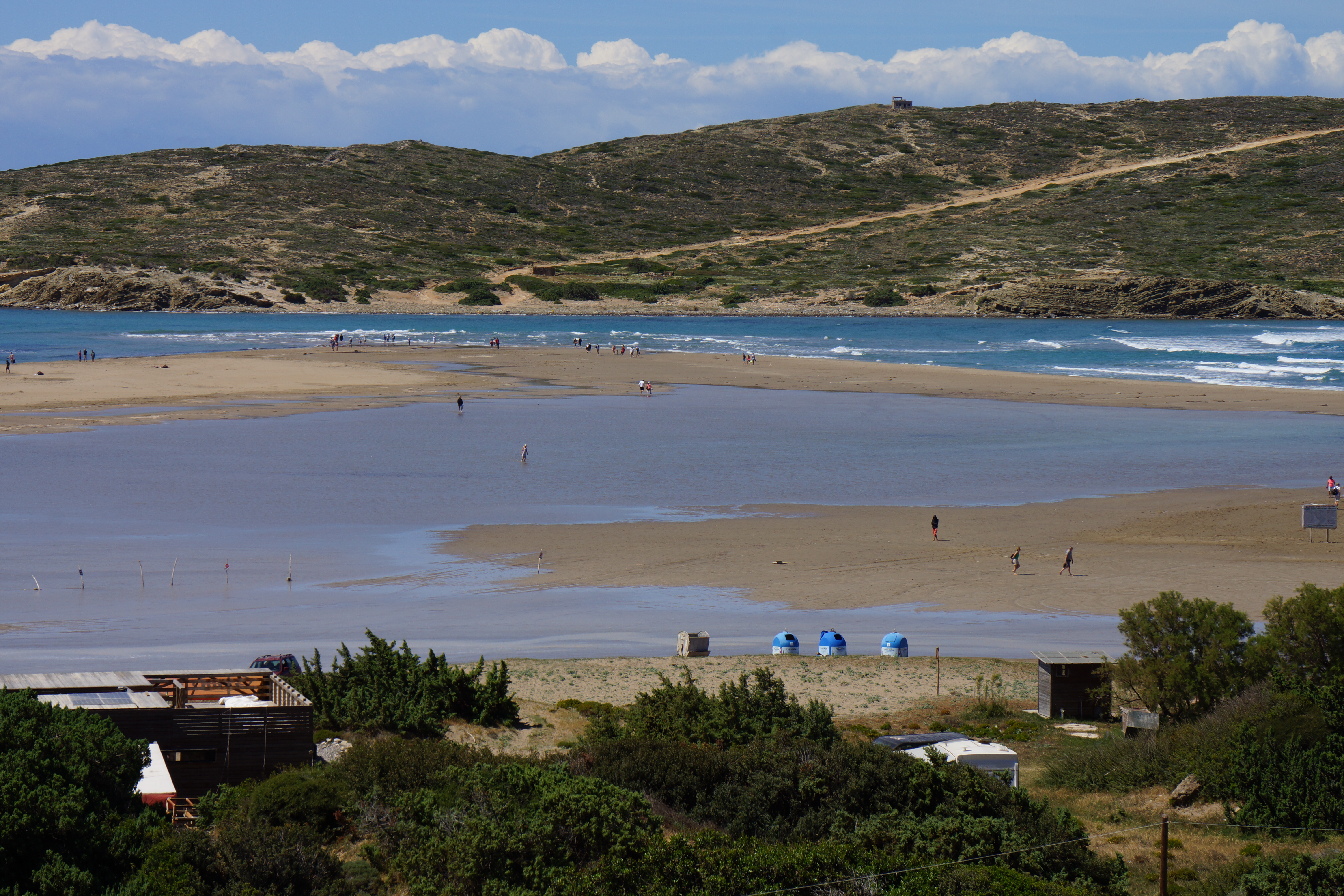
•17 KATAVIÁ – PRASONÍSI (my total time 1h48; 138a 201d; net walking time 1h34): This is walk 16 in /Rochford), note that I only timed it ONE WAY.
A stroll along the new asphalt road. Without unnecessary detours you will have no other choice now. At least it will not be dusty anymore…
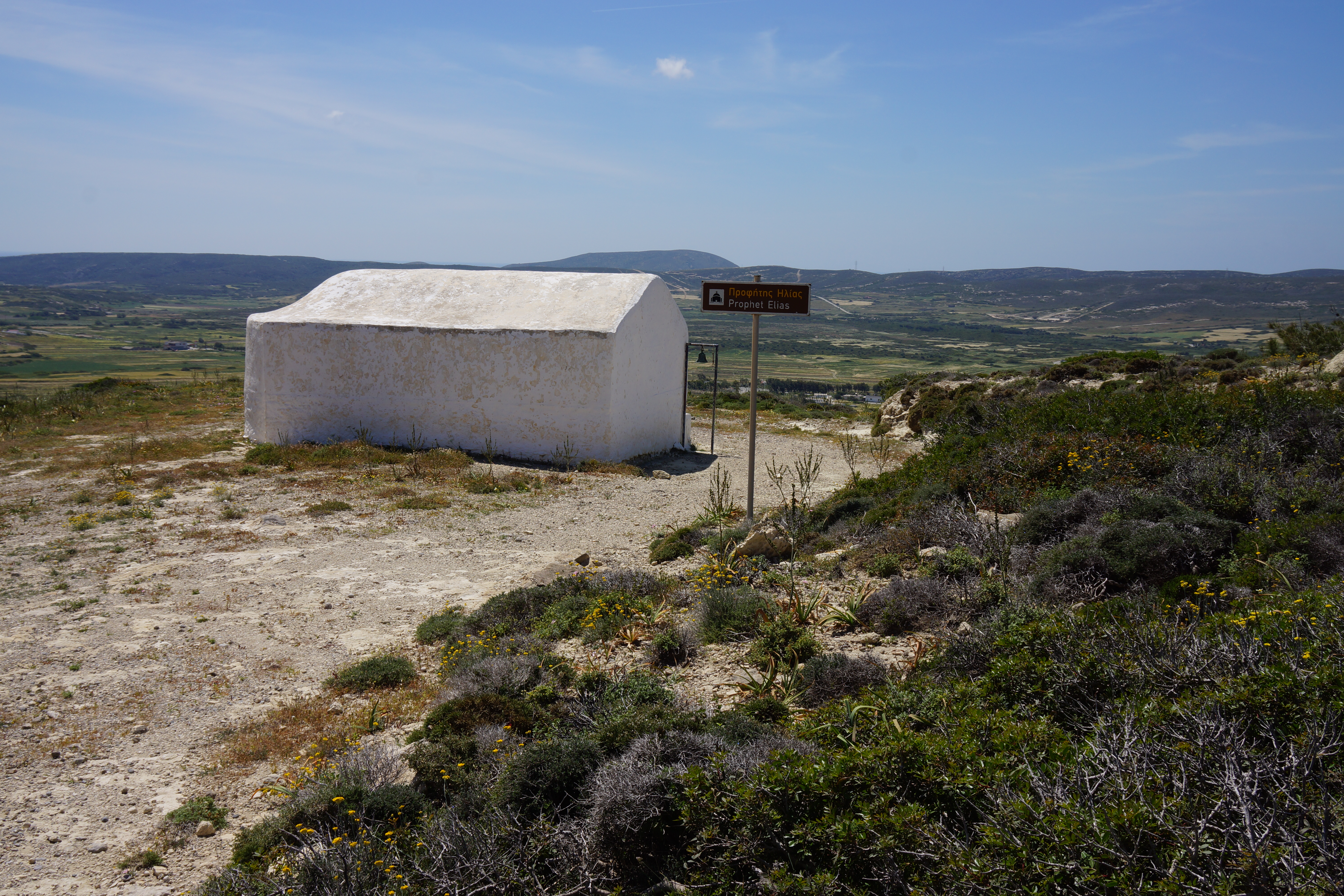
•18 KATAVIÁ – AG. MINAS – AG. NEKTARIOS – PROFITIS ILIAS – KATAVIÁ (my total time 1h49; 241a 239d; net walking time 1h30): Follow /Mazitto/ to visit nearby chapels, also refer to the Topo Islands – Rhodes map.
•19 APOLAKIÁ – AG. THEODOROS – ARNÍTHA – APOLAKIÁ (my total time 3h35; 369a 377d; net walking time 2h44): This is walk 15 in /Rochford/ and is still almost perfectly feasible as it is described in that book.
Note that if Ag. Theodoros is open, and I was surprised to find it open on my visit: NO FLASH PHOTOGRAPHY PLEASE.
After the 1h20 point disregard the instructions in /Rochford/ to go right “at the next fork”. If at all possible today this will unnecessarily scale the small hill to your right just for descending on the other side. Instead just stroll down the valley and take the NEXT right to finally ascend the bigger hill in front of you and towards Ag. Nikon.
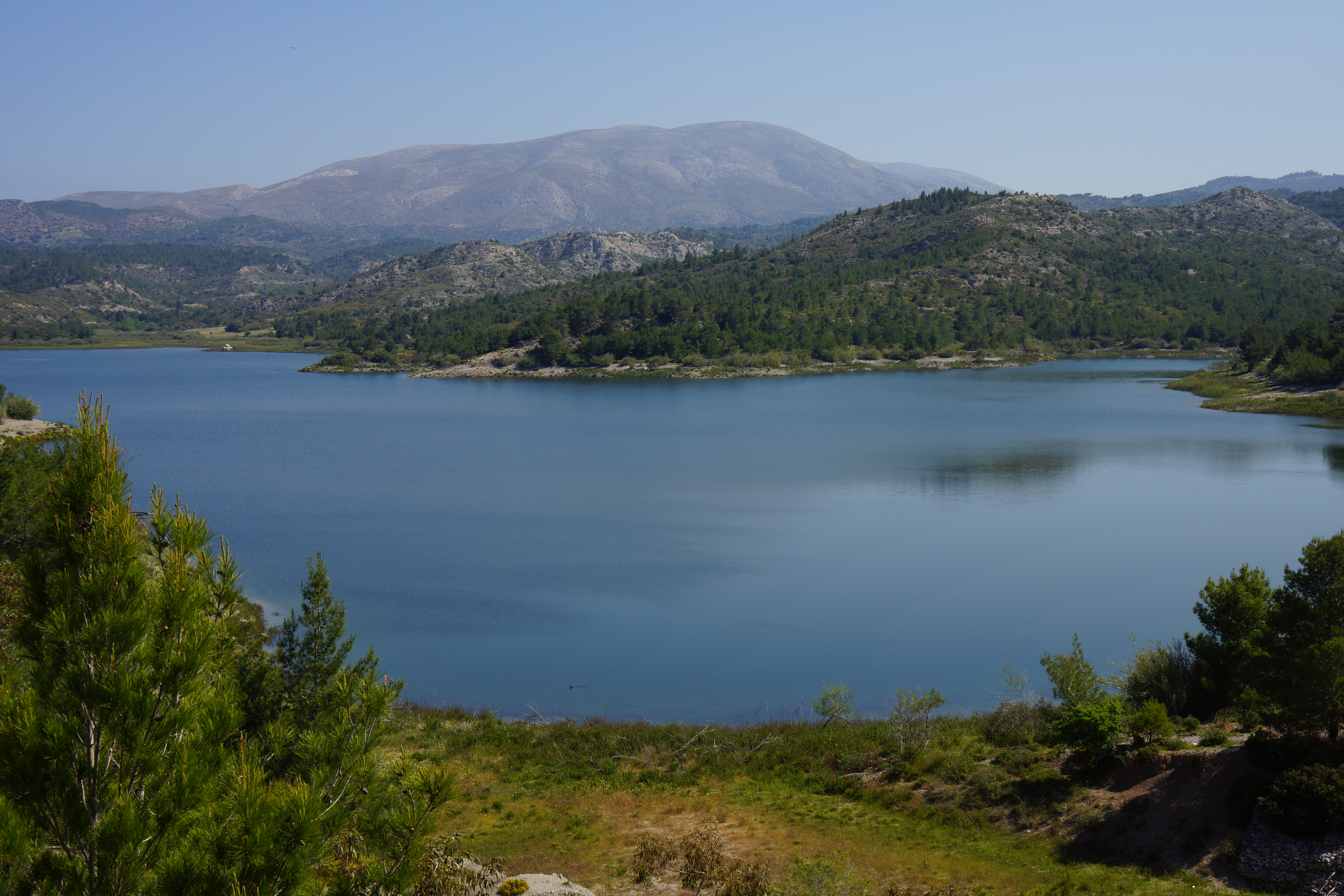
•20 APOLAKIÁ – AG. GEORGIOS VARDAS – APOLAKIÁ DAM – AG. THEOTOKOU – APOLAKIÁ (my total time 3h10; 211a 209d; net walking time 2h18): This is a slightly expanded version of walk 15 SW1 in /Rochford/.
After Ag. Georgios Vardas do scale the hill for several excellent viewpoints. From the top of the hill you can continue on an initially eroded and later rather overgrown narrow path where you can CAREFULLY get yourself down to the road and the dam. See /Mazitto/.
•21 KOSKINOÚ – KALITHÉA THERMES (- RHODOS TOWN) (my total time 1h35; 168a 258d; net walking time 1h05): This walk is based on walk 13 in /Graf2/. Take City bus line no. 3 from Mandraki harbour to Koskinoú, at the time of writing (2019) €2.30.
Unfortunately the book is obsolete (or just badly written?). The square in Koskinoú has no fountain nor a mini market. However moving in the more or less obvious direction should get you going. Note that the side trip to Profitis Elias will be just that, a detour. You are deposited on a cliff edge here with NO SAFE DECENT. DO NOT FOLLOW THE BOOK. Just stroll back and continue on the road.
From the Thermes you can take the bus back to Rhodes Town or (NOT RECOMMENDED THOUGH) actually CAREFULLY walk the whole stretch. Mostly there is at least an excuse for a sidewalk. Add another 1h30 or so for that option.
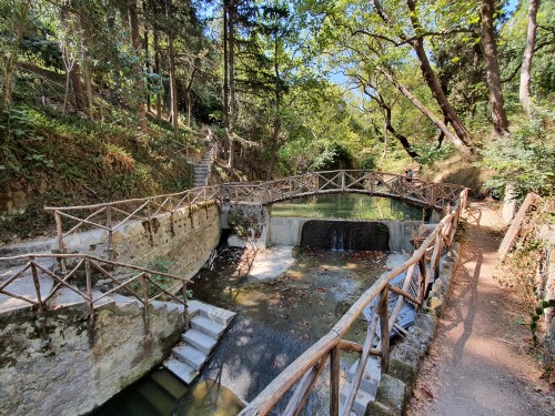
•22 OLD TOWN – RODINI PARK – OLD TOWN (not timed): Rodini park is within walking distance from the center of town. Even if the walk itself is not very interesting the park is shady and very pleasant to stroll around in. You can e.g. walk upriver as far as the footpath goes, cross the creek on an interesting bridge, then walk back down on the other side.
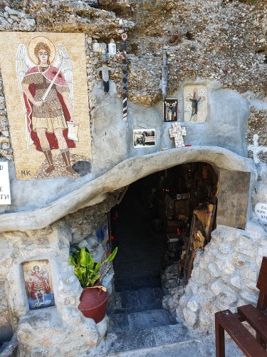
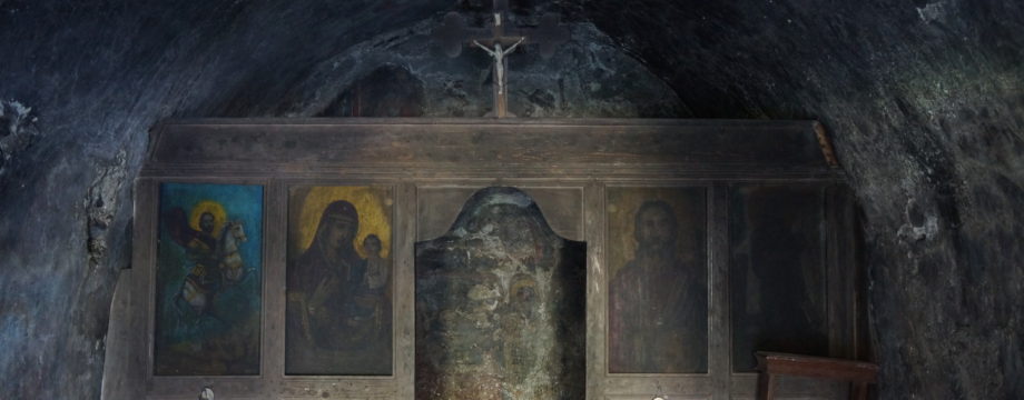
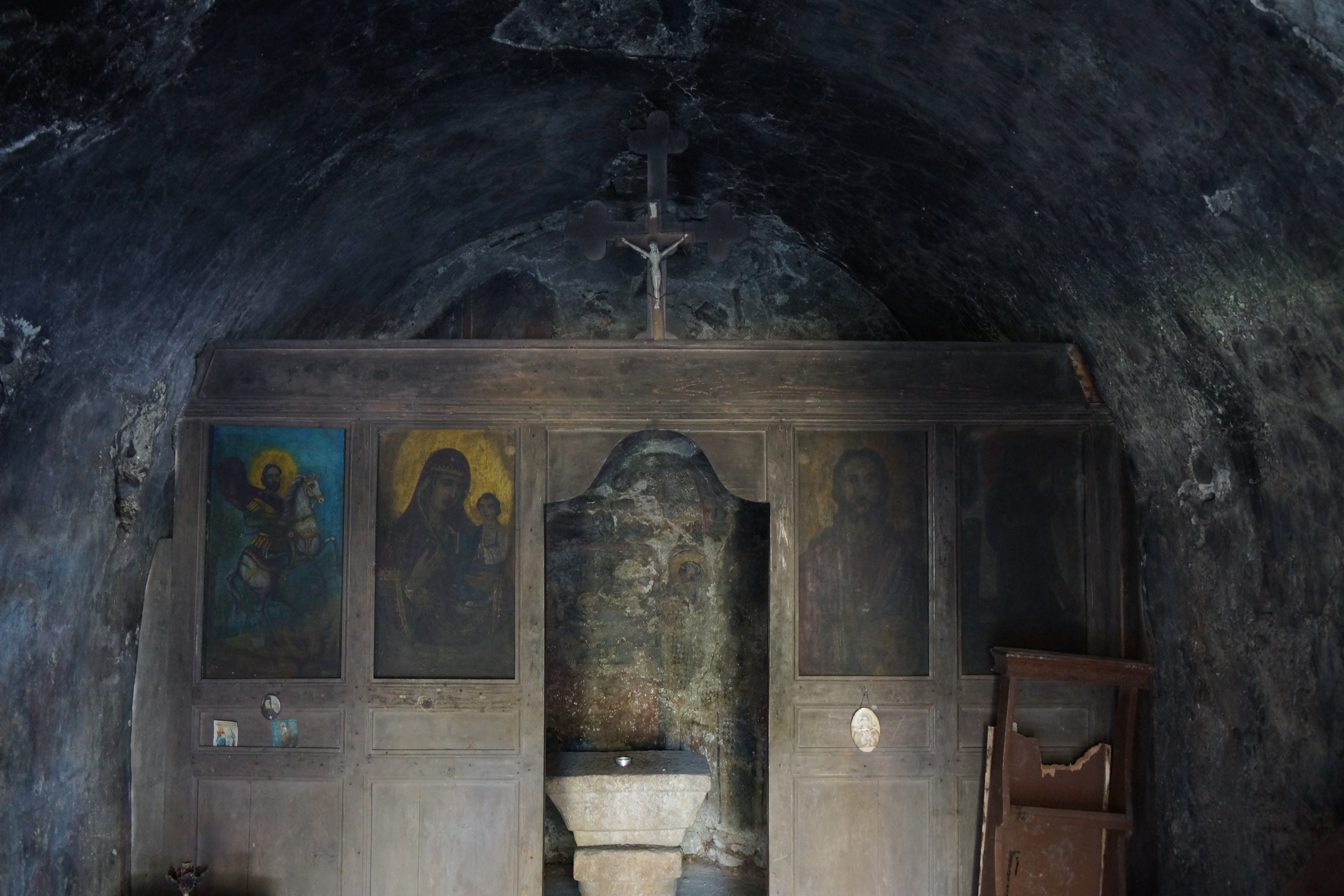
•23 RHODES TOWN – KRITIKA – RHODES TOWN (not timed): From Akti Kanari beach there is a nice coastal path towards Ixia. It goes as far as the outskirts of Kritika. It passes the well hidden small Archangel Michael Panormitis cave chapel.
• Good starting points: • Rhodes Old Town – close to the harbour, good value small hotels, good places to eat (if you can find them…) and close to the two bus stations that will provide transportation to most of the island
• How to get there: • By air • By ferry from other islands • By ferry from the mainland
• More info: • Rhodos Travel Revue – All kinds of information about Rhodes
This page was last modified at February 27, 2026.
©1997-2026