MALLORCA – Balearic Islands
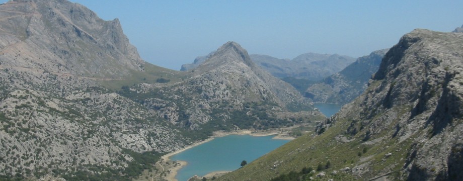
Another so-called “tourist” island that in fact checks out as (or at least one of) the most ideal islands for a walking holiday. This may come as a surprise to the average package tourist, but it’s no secret among walkers. You might even call Mallorca with its incredibly situated Sóller village the capital of Island Walking. It is also tempting to call Sóller a mountain village, at least mountains more or less hangs over it in just about every direction, but in fact it is only 30-40 meters above sea level! The narrow valley the 3 km’s down to the port is almost completely flat.
Sóller and its surroundings has earned a well deserved reputation for an uncountable number of great hikes. So much in fact that many land owners have closed off their property because of too much traffic, a very unfortunate situation. So if you want to walk in solitude, Mallorca may not be the place for you, at least not in the peak of the walking season (like spring). Expect large parties of walkers just about everywhere in the mountains, and in every direction. During two of my stays on the island even bus loads of screaming teenagers were deposited high in the mountains, and could be heard long before you could actually see them. They did not contribute a lot to the otherwise excellent mountain atmosphere.
Palma is a surprisingly nice place to stay. A good amount of bus (and train) connections will take you all over the island, and even the city itself is very attractive. You should of course not miss the great cathedral!!! Palma is also a good place for eating, and there is plenty to choose from. I can personally recommend especially Tasca de Blanquerna (C. Blanquerna, 6, one of the Marc Fosh restaurants), Taberna de la Boveda (Paseo Sagera, 3, see also walk 16) and Celler Sa Premsa (Plaza Obispo Berenguer de Palou, 8). Forn des Teatre (Plaza Weyler) is a nice lunch spot if the weather is nice. Among many, many others…
In Port d’Andratx (see walk 17), if you want to vary with some Greek stuff, the nice Greek/Mediterranean Restaurant Nisos is a good choice. They even manage to serve good Tarama, something which seems increasingly forgotten in Greece proper.
But if you want to do a lot of mountain walking the best place to stay is in my mind Port de Sóller. Sóller itself has not a great deal of accommodation and in the port you will in addition have some good coastal walks to choose from, straight out of bed. Also good for eating, excellent fresh fish e.g at Es Racó close to the harbor.
Another useful place to stay is Port de Pollença. Excellent tapas at the (fairly expensive) L’Almirant at the promenade.
Selected walks: For walks on Mallorca see “Walk! Mallorca North & Mountains” and “Walk! Mallorca West” by Charles Davis. Most of my walks below refer to these guides (referred to as “/Davis1/” and “/Davis2/”, respectively), and I consider them by far the best of the current walking guides to the island. Also take a look at “Landscapes of Mallorca” and “Walk & Eat Mallorca” by Valerie Crespí-Green (referred to as “/Crespí-Green1/” and “/Crespí-Green2/”, respectively), “Walking in Spain” by Miles Roddis et al. (referred to as “/Roddis/”) and “Walking in Mallorca” by June Parker (referred to as “/Parker/”). There is also “Mallorca” by Rolf Goetz (“/Goetz/”). Even the “Rough Guide – Mallorca & Menorca” by Phil Lee lists some walks (I refer to this as “/Lee/”). Also check out the “Mallorca North & Mountains Tour & Trail Map” by David and Ros Brawn (referred to as “/Brawn/”), which is a good partner to /Davis1/.
The Sóller Tourist Office sells their own publication “Soller – Mallorca, Walking between the sea and the mountains” by Gabriel Ordinas Marce. Users have especially recommended Walk 14, (quote) “which takes a beautiful staircase up to an area of common land above Fornalutx and then returns down a pretty valley.”
In /Goetz/ same users recommend Walk 14 – Valldemossa to Deià, (quote) “this goes via the Archduke’s path, the path dropping down to Deià is memorable – one of the best that we have taken.”
•1 PORT DE SÓLLER – LA MULETA – PORT DE SÓLLER (my total time 3h35, includes short stops for photography; +-453m, 2 laps): This is walk 8 in /Davis1/, but with the addition of starting (and ending) at the Platja d’En Repic in the port village, first by walking the road to the lighthouse then returning via Wp.14, and using the “Spectacular and Pathless” route. See also walk 52 in /Parker/.
No big navigational problems en route, but read the text for the pathless route very carefully. “Maintaining direction (SE)” here (just before the fourth cabin) is correct, but must be taken in the most general of senses, as you from the large cairn by the third ruin actually continue a few meters NE to pass the next house (which you can see thirty-forty meters away). Then you cross the valley and continues SE. Also mind that the map tracing here is incorrect, as this does not cross the creek. And Wp. 8 is misplaced on the map, the coordinates look right to me (although I have not checked them with an actual GPS), but it should have been placed just before the fork in the track (clearly seen on the map) where you should go left and after that “the track climbs past a small house”. With this small correction all the pieces to the puzzle seem to fall in place.
•2 PORT DE SÓLLER – TORRE PICADA – SA ILLETA – PORT DE SÓLLER (my total time 4h17, includes short stops for photography and a couple of small snack breaks; +-600m, 3 laps): This is walk 11 in /Davis1/, but with the small addition of starting (and ending) at the Platja d’En Repic in the port village. I also did swing by the headland where you (in theory) can swim. No time for swimming is included though, and in fact swimming here proved to be difficult. During my two week stay the sea was either too rough or the small bay was carpeted with jellyfish. Sun bathing on the cliffs on the other hand… See also walk 49c and walk 51 in /Parker/.
No navigational problems en route, but you should read the text carefully. There are so many options and it is easy to go wrong if you let the concentration drop.
•3 PORT DE SÓLLER – BALITX D’AVALL – MIRADOR DE SES BARQUES – PORT DE SÓLLER (my total time 6h09, includes short stops for photography and a small lunch; +-746m, 2 laps): This is walk 13 in /Davis1/. My timing starts and ends at Platja d’En Repic. Also see walk 47 and 49a in /Parker/, walk 18 in /Crespí-Green1/ and “Sóller to Sa Calobra” in /Roddis/.
A fairly spectacular walk and I recommend doing the full extension here. No problems en route, just enjoyment.
•4 PORT DE SÓLLER – SÓLLER – FORNALUTX – MIRADOR DE SES BARQUES – FORNALUTX – BINIARAIX – SÓLLER (my total time 5h05, includes short stops for photography and a small lunch; +649m -610m, 1 lap): This is walk 10 in /Davis1/, but with the addition of starting at Platja d’En Repic in the port village and walking to Sóller via Wp. 16 of /Davis1/ walk 8 (“If you’re returning to Sóller”, but mind that a reference to Wp.13 here should actually be Wp.14).
More pure enjoyment, but what a strenuous half hour ascent from Fornalutx…
•5 PORT DE SÓLLER – BINIARAIX – ES BARRANC – BINIARAIX – SÓLLER (my total time 4h56, includes short stops for photography, a small picnic and lots of investigation; +760 -724m, 2 laps): This is walk 17 in /Crespí-Green1/, with the addition of starting at Platja d’En Repic in the port village and walking to Sóller via Wp. 16 of /Davis1/, but from the “Monumento” (see e.g the /Brawn/ map) this time walking in directions of Biniaraix using a shortcut found in /Parker/ walk 50, where I after the football field (instead of taking left onto the path to Fornalutx used in Walk 4 above) curved right with the continuing road and followed street signs to Biniaraix. Also see Walk 6 below.
•6 SÓLLER – BINIARAIX – ES BARRANC – ES CORNADORS – L’OFRE – SÓLLER (my total time 7h55, includes short stops for photography and several stops for small meals and standing around just gaping in wonderment; +-1383m, 2 laps): This is walk 16 in /Crespí-Green1/. See also walk 14, 15 and 18 in /Davis1/, walk 42 in /Parker/ and “Barranc de Biniaraix & Embassament de Cúber” in /Roddis/.
This is one of the best walks on Mallorca, and in addition it is rather easy to find and follow, albeit very long and strenuous. One of the best walks I have ever done, with fantastic views.
The ascent of L’Ofre is very steep and stony, and I would suggest using the path from the Alternative walk on the return down, at least that is what I did.
•7 PORT DE SÓLLER – CALA DE DEIÀ (my total time 3h53, includes short stops for photography and some time for investigation; +551m -543m, 1 lap): This is the first part of walk 9 in /Davis1/ linked up with first part of walk 7 (in reverse). I started with walk 9 as in my Walk 1 above, but this time following the “Quick & Easy” option. However I did not link up with walk 7 as suggested in the book, instead followed road signs directly down to the Bens d’Avall Restaurant. Some investigation was needed to find a place to cross the barranco here (it all seemed to easy on the /Brawn/ map), but there is a good spot to scramble down into and up from the canal just ABOVE the restaurant car park. Also see walk 52 and 53 in /Parker/, walk 11 (Alternative) in /Crespí-Green1/, “Sóller to Deià” in /Roddis/ and “A coastal walk from Deià to Port de Sóller” in /Lee/.
Despite rumors to the opposite, the whole stretch of the Deià coastal path is in fact alive and well. And not too difficult to negotiate, but be sure to follow the waymarking extremely carefully. Tree falls and land slides might make this path, clinging to a very eroded coastline, more or less unusable for a short while. This is why you have to make your best judgment, but you can count on the fact that by popular demand of both adventurous walkers and swimmers any damage will be repaired (or alternatives found) pretty quickly.
•8 DEIÀ – SÓLLER (my total time 2h02, includes short stops for photography; +240m -334m, 1 lap): This is walk 13 in /Crespí-Green1/. See also walk 1 and 7 in /Davis1/, walk 54 in /Parker/ and “Sóller to Deià” in /Roddis/.
A very idyllic walk, easy to follow. It is just a matter of following the good waymarking or just keep going ahead. At the start the sign was (probably temporarily) missing (seemingly due to road works, and even the “.2” stone was missing), so be sure not to confuse KM 60.2 with KM 61.2, where there is a walker sign pointing somewhere (???). To my best understanding that one was supposed to point to a parking area for walkers (“Aparcament”), which was not finished (or under refurbishment).
•9 BÓQUER VALLEY (my total time 2h46, includes short stops for photography and a small rest at the beach; +-201m, 2 laps): This is walk 36 in /Davis1/. Also see walk 8a in /Parker/, walk 28 in /Crespí-Green1/ and “A valley walk from Port de Pollença to the coast at Cala Bóquer” in /Lee/.
A short, but fairly nice walk/stroll. You just cannot go very wrong here.
•10 TORRENT DE PAREIS (my total time 1h56, includes short stops for photography, one short snack break; +-108m, 0 laps): This is walk 22a in /Davis1/. Also see walk 27 in /Parker/, walk 19 (Short Walk) in /Crespí-Green1/ and “Torrent de Pareis” in /Roddis/.
Interesting short scramble up the mouth of a spectacular ravine. Doing the whole thing, the entire gorge, is for the extremely adventurous only.
•11 PUIG GROS DE BENDINAT (my total time 3h31, includes short stops for photography, some investigation; +599m -576m, 2 laps): This is walk 3 in /Davis2/. Also see walk 72 in /Parker/.
Unbelievable views from such a smallish hill! Good walk, but you might just skip the suggested small extensions and take a somewhat bigger one by following the first (cairned) path to the right immediately after the “gate and mapboard”, leading you in just a few minutes to the actual summit of Puig Gros de Bendinat. There you have an incredible 360 degree view.
•12 SA BRUTA (my total time 1h56, includes short stops for photography; +-285m, 1 lap): This is walk 8 in /Davis2/.
A bit of an anti-climax after all of the above, but nice views anyway. I did all the proposed alternatives on the return, which is a minimum for getting a half-way useful walk. A bit of tickling in the stomach on the decent from the hill top…
•13 CAMI DE S’ARXIDUC AND THE PUIG DE’S TEIX: (my total time 5h06, net walking time 4h37) This is walk 9 in /Crespí-Green1/. See also walk 4 in /Davis1/, “Valldemossa Loop” in /Roddis/, walk 57 in /Parker/ and “From Valldemossa to Puig d’es Teix by the Archduke’s Path” in /Lee/.
This is one of the best walks on Mallorca, following partly the famous Archduke’s Path, and in addition it is easy to find and follow. Just follow the instructions/maps found in the guide books and enjoy. One of the best walks I have ever done, with great views.
OBS: I did this walk last in 2000.
•14 PUIG TOMIR: (my total time 4h12). This is walk 25 in /Crespí-Green1/, but returning via (some of) the Alternative walk and then the track back to Menut (see map). The Alternative return route is warmly recommended as it excludes almost all the road walking. Instead you will be following a very nice path and (later) forest track. The track forking right from Coll Pelat back to Menut was in the process of being bulldozed and was not as attractive as expected. This was possibly a bad choice on my part and you should consider a different route here, i.e following the Alternative walk all the way back. Also, my walk was cut short once up on the Tomir plateau due to very heavy winds. I could hardly stand upright… Mind that the full walk will take longer time, I would guess at least an hour more. See also walk 31 in /Davis1/, and walk 21 and 24 in /Parker/.
In previous Sunflower guides this walk was only recommended “for expert mountain walkers”. Now it just says “experienced”. Personally I am not sure I would recommend it to anyone. Doing the descent the same way is hellish, and it must be much better to follow e.g /Parker/ for a different return route (but longer). Now *if* you want to go back the same route, using the metal cable fixed to the rock is almost mandatory. You cannot properly see where you will need to put your feet when coming from above. Bring a pair of old leather enforced ski gloves or similar for this purpose, otherwise you will cut your hands open! It worked nicely for me (but you can just throw them away afterwards…).
OBS: I did this walk last in 2000.
•15 CAP ANDRITXOL (my total time 2h10; 315a 307d; net walking time 1h43): This is walk 9 in /Davis2/. I followed 9b out and (mostly) the return of 9a. However the street name given in the book for where you should turn left back at Cala Fornells is wrong (“Carretera de Cala Fornells”). That was the street turning right. I just strolled that one back to Peguera then…
A nice little walk, but with a tough ascent. I do not think you will get into much trouble with Claudia using either route…
•16 PALMA (my total time 2h45; 227a 234d; net walking time 1h48): This is walk 10, the Palma city walk, in /Crespí-Green2/. Mind that you will have to add all time used in museums or castles underway, my time only includes the bare minimum of sightseeing.
Palma is a very nice city to stroll around in, but leave this one for a holiday. The restaurant tip is very good, be sure to follow it. Finding your way is pretty easy, just be sure to carefully follow the MAP, as Valerie´s left and right might not always coincide with your left and right, and there is at least one street name in the text that is incorrect.
•17 CALA D’EGOS (my total time 2h12; 468a 473d; net walking time 1h52): This is walk 11 in /Davis2/.
A nice little walk from Port d’Andratx. But take care. Some very steep parts. And look out for trial motorcyclists!
•18 EL TORO (my total time 1h44; 211a 222d; net walking time 1h26): This is walk 7 in /Davis2/, with all the detours. The correct name for the bus stop in El Toro is “Entrada El Toro” (bus 105 recommended from Palma, as this will be faster than the 104).
A superb little walk. Mind that the last steps down to the sea are cut out from the cliff wall and are very round and sandy. I recommend turning around at the vantage point just above. For the additional 5 mins detour, 4 should be enough. The path peters out completely after that.
• Good starting points: • Palma – from here bus/train will take you around the entire island • Port de Sóller – a miniature resort, still pretty quiet, bus/tram to Sóller and bus to other useful villages and trailheads • Sóller – the official unofficial capital of Island Walking! • Port de Pollença – not too bad for a resort, reasonably close to mountains and other interesting stuff
• How to get there: • By air • By ferry from other Balearic islands
• More info: • MallorcaWeb • MALLORCA.COM • BALEARIC ISLANDS by All About Spain • TIB has bus timetables for the entire island
This page was last modified at March 9, 2026.
©2000-2026 .