SICILIA – Italy
Sicily is an immense island, and I am not at all able to make any judgment on the place from just an extended weekend trip to Palermo. Palermo is a huge, noisy and chaotic city, but there is good walking to be found all around. If you can stand the city, do not hesitate, the walking in truly excellent. And hardly anywhere else will you use less calories per fantastic view (for others, this might be a put-off).
For the experts there’s another other side (literally) of the island: The terrain around the huge Mt. Etna should be able to satisfy most. And don’t forget the island groups around Sicily, either. Both the Aeolian and the Egadi islands (Island Hopping!!!) has a good selection of easy, but also some difficult, walks.
Instead of making any particular recommendations about where to stay or where to eat (anyway, this city has a plethora of good cheap accommodation and eateries), I will for once concentrate 100% on possible (or perhaps not so possible…) walks, both those I have tried and those I have not. As I said, Palermo is a true chaos, and little help is to be found for those who do not speak (or read) Italian. You will need info about exactly how to get to the various walks (and back), and where things might be more difficult than anticipated. I assume you are stationed (exactly…) somewhere around Stazione Centrale (for giving you bus directions). Absolutely all the information I could gather about this on my short trip can be found below, and as I said, you will sure need it, as this is more difficult than the walks themselves (which are relatively easy to follow, at least in my experience).
Selected walks: For walks on Sicily take a look in Peter Amman’s “Landscapes of Sicily” (and when I refer to walk numbers etc. from this book, the information is taken from the book’s 1st edition), “Walking in Sicily” by Gillian Price and “Sicily and the Aeolian Islands” by Mithra Omidvar. References below are to these books as “/Amman/”, “/Price/” and “/Omidvar/”, respectively. There are also some volcano walks in “Walking in Italy” by Gillman, Bardwell, Cavedoni & Tapp.
•1 MONTE PELLEGRINO (my total time 3h38): This is Walk 24 in /Amman/, with the inclusion of the S. Rosalia statue lookout from Walk 24 in /Price/. To get to the trail-head take bus #101 or #102 from Stazione Centrale to Teatro Politeama. Then bus #806 to Ex Scuderie Reali in Parco della Favorita. I believe both lines #101 and #102 turns right at Politeama, into the wide avenue Viale della Liberta, get off at the first stop here, and wait for #806. Or you can pick it up from its starting point at Piazza Sturzo, just behind Politeama. From the bus stop at Ex Scuderie Reali, this is the SECOND bus stop along the Parco della Favorita (unfortunately the bus stop sign itself is hidden from view, the bus passes the clearly visible FIRST stop by a gate, then the street bends a little right before a new long straight, at the end of this straight is the Ex Scuderie Reali, just by another bend to the right), walk up though the pine forest to find the (initially) wide path lined with stones. No big problems en route.
After you get to the top of the valley, turn left on the vehicle track just before the derelict house. Cross the road and take the leftmost track on the other side (beware that the map tracing seems to be a little off here). It has a locked gate, but an opening in the fence. The first junction is a bit AFTER the water trough. This is wrongly described in the text, the map has it more correct, but I would place the water trough even further back the road. Anyway, it’s straight ahead here. Then fork right at the second junction, as described. When you eventually are on the main road again, before taking this road right to the Santuario di S. Rosalia, please do a quick stroll left to the great lookout point by the Statua Di Rosalia.
Later, down the pilgrims trail, take extreme care down the polished stone path that can be slippery as ice at certain points. That the stones also may be covered with pine needles for long stretches does not make things better. At the end of the walk, when you reach Piazza Cascino, the bus stop just after the end of the pilgrims trail, is NOT the correct one. You have to cross the Piazza, walk down below the Fiera Del Mediterraneo, to Via Anwar Sadat, to catch e.g bus #812 to Teatro Politeama/Piazza Sturzo (again, it’s best to get off while you are still in the Viale della Liberta), then again bus #101 or #102 to Stazione Centrale. Only rudimentary info in the book here.
•2 PIZZO DEL CORVO (my net walking time just close to 1h, even including a little investigation at the top, to find the correct path down on the far side of the mountain): This is Walk 25 in /Amman/. The book only says that “buses run regularly between Monreale and San Martino”. This is not information of the detail and quality we have gotten used to from the Sunflower Landscapes guides. From Palermo’s Stazione Centrale take bus #109 to Piazza dell’Indipendenza. From there take bus #309 or #389 to Monreale. As Teatro Politeama the Piazza dell’Indipendenza is a huge square, but the buses onward takes off from just where line #109 ends. If you don’t plan to do any sightseeing in Monreale I believe #309 is more convenient, it will drop you off in the center of the town, close by were you must switch to another (local) bus. Line #389 has its end stop at Piazza Monreale, close to the Duomo (picture left). From there its a five minutes walk up the main pedestrian street until that ends exactly where most of the local buses, i.e lines #1, #2, #3, #5 and #6 (#4 has a marked stop just below where the #389 ends), stop (you will se a “bus” marking in the asphalt, as well as a sign for “hourly bus” or something, in Italian, by the road). Line #2 towards San Martino delle Scale is the one you want. Take this to the easily recognizable saddle at “Portella San Martino”.
From Portella San Martino a sign points up the good path up to the Castellaccio. You cannot go wrong on the way up. The path back down on the other side of the Castellaccio is partly hidden until it passes by something that at least looks like small weather station. You will find the path behind the castle (from where you ascend). It descends eastward and is lined by stones. It zigzags on narrow stone terraces and becomes even more overgrown. You might have only the stones to navigate after. Later the path again becomes very good and passes a little pine forest. After the pines (and before a second collection of pines, where the path zigzags down to the road) the path forks. You take the right fork (straight ahead). You are shortly back to the bus stop, where you take the local bus back to Monreale. Again its #309 or #389 back to Piazza dell’Indipendenza (the other side of the square now), where #109 to Stazione Centrale also stops.
•3 PIANA DEGLI ALBANESI (I have not done this walk myself, but I tried…): This is Walk 26 in /Price/, Walk 29 in /Omidvar/. According to /Price/: “There are plenty of buses to Piana degli Albanesi from Palermo’s central railway station (Mon-Sat)”. This is wrong, at least on a Saturday. The bus was scheduled at 12.30, and if the Rough Guide is correct about the last bus back at 16.00, there is no time to do any walking. So unfortunately this walk proved impossible as a day trip. However, the bus company is Prestia & Comandè, they are also running the airport bus, but it’s not the same stop. The stop for Piana degli Albanesi is further back towards, or besides, the station, I do not know the exact spot. This is all according to the airport bus ticket salesman, but after hearing the departure time I had no reason to do more investigation here…
•4 MONTE IATO (I have not done this walk myself): This is Walk 29 in /Amman/, Walk 25 in /Price/. According to /Price/ this walk is feasible as a day trip from Palermo. But I would not count on it (see Walk 3)… However, both the starting point for this walk (San Cipirello) and the ending point (San Guiseppe Iato) is served by the same AST bus from Palermo. AST has bus terminals at Piazza Lolli and Corso Re Ruggero, but I do not know from which of these points the correct bus departs.
•5 TIMPONE DI CARONIA (I have not done this walk myself): This is Walk 31 in /Omidvar/. Access from San Martino delle Scale (see picture right). For information on how to reach San Martino, see Walk 2 above.
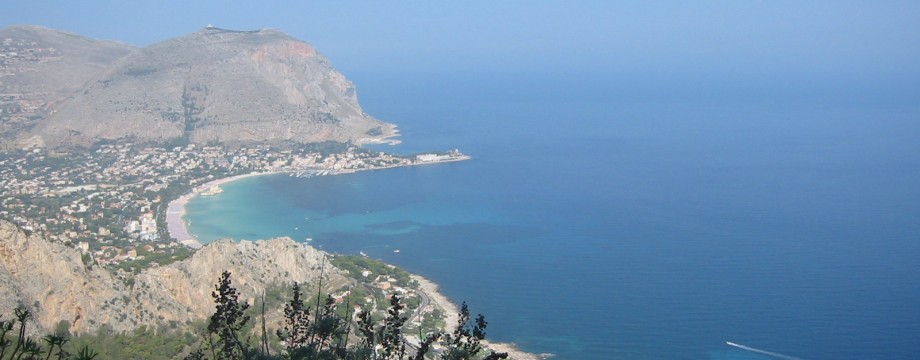
•6 MONTE GALLO (I have not done this walk myself): This is Walk 32 in /Omidvar/. Access from Mondello (picture left, see also top picture with view towards Mondello and Monte Gallo from Monte Pellegrino). Bus #806 used in Walk 1 above goes all the way to Mondello. Return on the same bus to Palermo.
• Good starting points: • Palermo – at least a weeks worth of walks not too far away, but there are also • Many, many other places to start off a walking holiday
• How to get there: • By air • By ferry from the mainland
• More info: • Sicily in detail • palermotourism.com – official tourist site • walksicily – Peter Amann’s own web site (mostly in German) • I.N.G.V – watch eruptions on Etna or Stromboli live on the I.N.G.V webcams
This page was last modified at March 9, 2026.
©2002-2026