GOZO
The second Maltese island, a laid back little island that is much more quiet than her bigger sister. But I still prefer even this island in winter.
I have stayed in the little port of Mġarr. Not including the hotel restaurants which I did not try. There is currently only one hotels in town, the Grand (****). Do invest the extra amount of money to get sea view.
Incredibly enough I can give all the restaurants in town that I have tried my recommendation. When did that happen last? The only one in the vicinity of town I cannot really recommend is a kilometer or two out of town (actually in Qala), the Xerri il-Bukkett on the Zewwieqa road. This is a place that gets lots of visitors (at least for lunch), but mostly for the excellent views towards Comino, not for much else. They have some decent home-made pasta though. Their local house wine should be avoided like the plague. And the service is as you would expect for a place like this, appalling.
The biggest place in Mġarr is the L-Ankra (“The Anchor”). An old institution in town now under new management, more elegant and with maybe even better food. The Ta’Tona Bar & Restaurant is a fairly informal place, but with service that is both very professional and very friendly. Excellent for fish, but also incredible steaks from Irish beef. A family run place. I have not eaten there lately though, as they have chosen to move all their tables outside in “summer”. For excellent and stylish dining in an usually very peaceful atmosphere try the Cantonese place Huan Yuan. Unusually elegant looking for a Chinese restaurant. Such specialties as quails and frogs legs can be had. Great Samosas also. I do have some reservations currently about the former so great little restaurant Ta’Pawlu though. Very limited menu and erratic opening times has made me not visit since 2004. It used to be the best restaurant in town, not sure what has happened here. Currently (2013) the best place in Mġarr is probably the Tmun Mġarr, with some very good food and excellent service. You can also eat very nice fish at the Seaview, which is even open for lunch.
The walks below are from two trips to the island, the first from 2004, the second from 2013.
– 2004 –
Selected walks: For walks on Gozo check Douglas Lockhart’s #Landscapes of Malta, Gozo and Comino”, referred to below as “/Lockhart/”, and “Malta & Gozo Walking Guides” by D. A. Brawn, referred to below as “/Brawn/”. You should also check out “Walking in Malta” by Paddy Dillon and Gozo – 10 Great Walks by Emmet McMahon and Jonathan Henwood. PLEASE NOTE: when I refer to walk numbers etc. from /Lockhart/ they are all taken from the 4th edition. All walks from 2004 on the Malta page are also done with a base on Gozo.
UPDATE 2: I hope the latest 5th edition of /Lockhart/ makes most of my objections below unnecessary.
•1 SOUTH EAST COAST (MĠARR – TA’ ĊENĊ – SANNAT – VICTORIA) (my total time 3h19, includes only short stops for photography and snacks; +284m -187m, 1 lap): This is walk 25 in /Lockhart/. Immense cliffs, the highest in Malta, are to be admired on this walk.
The correct way initially is to the left of the Seaview restaurant. Just stroll along to the lower part of the car park and continue on the level, there is no need to take any ascending track.
Just before the “45min” point you can take the first left down towards the “rock-cut platform” (i.e following the coastline as closely as possible) or just stroll along on the easier main path.
Just after the bridge over Wied Sabbar go RIGHT at the t-junction. Not long after that the “easily missed” path to the right is absolutely impossible to miss, as it is the main path that actually curves right here.
•2 NORTH EAST COAST (my total time 5h22, includes only short stops for photography and snacks; +634m -548m, 3 laps): This is walk 26 in /Lockhart/.
Easy to get on the right track here too, but MANY (unnecessary) difficulties under way. The timings are also inconsistent, so try not to rely to much on these.
At the “defending wall” take the path going right, not what looks like the main path going through a gap in the wall. Below the watchtower at the “1h 35min” point continue ahead instead of forking left on the much more tempting track going straight down towards to coast. Do not turn left here until you are AT the coastal path itself. This is even after the track you have been following has more or less petered out.
At Ir-Ramla the continuing path is to your LEFT (as you approach the farm), continuing more or less straight ahead and down towards the beach, not right as the book says. The track on the right will make your trip longer and difficult to find.
The track left at the “3h 35min” point is however easy to find. You can see from the map that it follows a watercourse. The difficulty is finding the correct point to take right on the “footpath”. The pond is not visible from the main track below, and there are at least three such paths before the main track itself turns right up towards the street. You could use that approach also, a little longer though. As the timings proved useless at this point, do remember that the correct (concreted) footpath is the SECOND you pass. One minute later you should pass the pond mentioned.
Just after the “4h10min” point there are TWO types of “straight ahead”, the one curving left is the one you want… And at the Victoria/Nadur road you go right and IMMEDIATELY left, not after “100yds/m”.
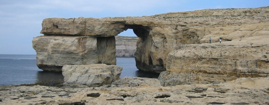
•3 NORTH WEST COAST (VICTORIA – MARSALFORN – XWIENI BAY – ĦEKKA POINT – GĦARB – VICTORIA) (my total time 4h55, includes only short stops for photography and snacks; +-354m, 1 lap): This is based on walk 23 in /Lockhart/, but using walk 1 in /Brawn/ as an alternative start, to avoid road-walking until you are actually at the coast itself. The coastal scenery on this walk is fantastic, and more than makes up for the difficulties experienced under way.
There is no problem finding the right track from the start, as the text in /Brawn/ is very detailed. The path however becomes very overgrown, and may be difficult to spot if you are here in a season when the grass is green and plentiful. Study the text and map carefully, it is absolutely correct, and hopefully you won’t have a big problem. Remember you should not continue to curve around the hill for very long, you are supposed to climb it, and hence need to use any faint path you can see to climb upwards. Eventually the main path will materialize again!
After Marsalforn you follow the route from e.g the alternative walk of walk 23 in /Lockhart/, but in reverse, to get back on the main route.
Even the remote Ħekka point has now fallen to the “birdbrains” (ref. /Brawn/), and makes the somewhat difficult navigation even more difficult. When the main track peters out here, just after a shooters hut, look for faint wheel tracks climbing the hill on your left. Use this faint track to scale the steep hill between shooters (listen for shots fired and possibly wear something with bright colors!) to a find a dirt road on the top. Cars may very well be parked on this road, in that case you will clearly see where you should be heading.
Just after passing some buildings on your left there is an important crossroads missing in /Lockhart/ (or the text is more than usually confusing). My advice is to read THE MAP carefully, the crossroads are clearly marked there, with left going towards the San Dimitri church (this can be used as an alternative though, see /Brawn/), and straight ahead going basically nowhere. The main route goes RIGHT. I could not recognize what is called stone huts in the text. However, as far as I remember you will in a minute, as you curve left, pass two concrete boxes on your right with signs pointing towards a fireworks factory. It is just to continue ahead on the most obvious track here, without turning left OR right. (It is now obvious to me that Mr. Lockhart did NOT take the track inland from Ħekka point, but instead continued on a path into the next bay before turning inland, even though this cannot be deduced from the text. This means that the map tracing is in fact totally wrong. So the two concrete boxes I noted are indeed where Mr. Lockhart came up, this is also the only thing that could make his text make sense at this point has he states he came via the fireworks factory.)
•4 SOUTH WEST COAST (VICTORIA – XLENDI BAY – DWEJRA BAY – SAN LAWRENZ – SANTA LUĊIJA – VICTORIA) – (my total time 4h56, includes only short stops for photography and snacks; +-430m, 2 laps): This is walk 24 in /Lockhart/, but with an alternative return via San Lawrenz from walk 8 and 9 in /Brawn/ before being back on track with the original route. Very interesting coastal landscapes on this walk!
Easy to find and mostly easy to follow this route, but not all is for the faint-hearted.
I cannot vouch for all the street names mentioned in Munxar, but keep ahead towards the “Sannat cliffs” and you will be ok. “At a pillar just before a ruined building” is wrong. There are just the pillars of THE ruined building, and when you pass those you have already walked to far… I just walking straight into Xlendi at this point, avoiding the small and pretty unnecessary diversion on the headland. You can see it all from the road.
The scramble (starting with the stairs in the cliff wall) out of Xlendi is a bit rough and again made more difficult by the presence of many “birdbrains”. Try to avoid the many “NO ENTRY” signs when you scale the cliff. Finally on the dirt road above, you keep right.
Left towards Qawra Tower at the “2h45min” point is initially an eroded walkway on top of a narrow wall. Don’t despair, this IS the right way. Pretty boring and ugly landscape at this point, with the quarries and all, I did not want to go here twice. So I selected a different return which is back to the main route at the mentioned spring.
For the alternative route follow walk 8 and 9 in /Brawn/, but in reverse, to get yourself to the “spring”. The text is very detailed and used in conjunction with the map the instructions are not very difficult to reverse. This is the basic approach: After visiting the fantastic Dwejra bay, you use the very interesting steps just behind the chapel to climb the cliff surrounding the inland sea. This is very easy to do and I can warmly recommend this little side trip for its views. Ugly quarries again before very nice San Lawrenz, and then it is part of walk 9 (again in reverse) towards Għajn Abdul hill and the spring below. You can also climb (some of) the hill if you want.
The rest of the return is as in the main text, but beware that the text and the map in /Lockhart/ describes two slightly different routes in Santa Luċija. Use either approach, but do get yourself onto the correct road, i.e towards the pumping station.
•5 IL-KASTELL (ĊITTADELLA) (my total time 0h27, this very short time even includes stops for photography and admiring the view; +51m -31m, 0 laps): This is the “Walking Tour of Il-Kastell” in Lonely Planet’s “Malta”.
So short that it is almost not a walk in itself, but in addition to the excellent views it provides access to a great cathedral and the three museums (four if you include the cathedral museum) inside the Kastell. I guess you would be able to “waste” a few hours here if you really wanted to. I did not try them myself, but went along to Xewkija to visit the great dome instead… The walk starts at the Pjazza Indipendenza in Victoria and ends at the steps of the “Rotunda”.
You should have no problem of finding your way here…
– 2013 –
Selected walks: For these walks see Gozo – 10 Great Walks by Emmet McMahon and Jonathan Henwood, referred to below as “/McMahon&Henwood/”. You should also check out Douglas Lockhart’s #Landscapes of Malta, Gozo and Comino” and “Walking in Malta” by Paddy Dillon.
•6 MĠARR – MĠARR IX-XINI – XEWKIJA) (my total time 2h00; 289a 186d, net walking time 1h36): This is walk 1 in /McMahon&Henwood/. This is similar to walk 26 Alternative walk in /Lockhart/.
Easy navigation all the way, but I still do not understand (assuming the path I walked in 2004 just continuing from the lower part of the car park has not slid into the sea) why it is necessary to take any uphill track initially only to find an almost invisible path to get back down to the coast again.
•7 MĠARR – ĦONDOQ IR-RUMMIEN QALA – MĠARR (my total time 2h55; 388a 369d, net walking time 2h33): This is walk 8 in /McMahon&Henwood/.
Easy to find and follow for the most part, but I passed (with a view) the Qala battery higher up in the terrain when trying to follow the book. It seems now that taking the first fork right down towards the coast and INTO the small valley mentioned is the correct route, NOT “continue on parallel to the coast” etc. Later forks proved unsuccessful.
The way “Back to Mġarr” is neither obvious nor is it (initially) downhill. As seen on the map it is a sharp left, and this is actually slightly uphill from the roundabout. Following signs and continuing downhill from the roundabout will have you walking the main road. If you want to follow any signs you can look out for the “infamous” Xerri il-Bukkett restaurant.
•8 QALA – NADUR – DAĦLET QORROT – QALA (my total time 2h36; 349a 350d, net walking time 2h04): This is walk 7 in /McMahon&Henwood/, except I used Qala as my starting/ending point. I left the optional San Blas out of the walk.
Not many problems en route, but no “Lady” appeared before me in Nadur. I did not see any specific reason to visit the central square either, so I just cut that out of the walk.
And towards Daħlet Qorrot “Keep straight ahead” actually means curve sharply left!
•9 VICTORIA – WIED L’GĦASRI – XWEJNI BAY – VICTORIA (my total time 2h54; 346a 344d, net walking time 2h22): This is walk 5 in /McMahon&Henwood/. I left the optional continuation to Marsalforn out of the walk.
Fairly easy navigation all the way just mind that Brookie’s Restaurant is currently seemingly closed and for sale. So this waymark may not be valid in the future. The street sign for “Triq Wied Sara” should still be visible though.
•10 VICTORIA – XĦAGRA – RAMLA L-ĦAMRA – XĦAGRA (my total time 2h32; 320a 272d, net walking time 1h54): This is walk 6 in /McMahon&Henwood/. My timing start at the bus station, and I did not visit the Citadel on this trip.
Mind that currently (2013) the site of the Ġgantija temples is under complete refurbishment and is closed to the public. Similarly is also the Ta’ Kola windmill under refurbishment so there will be no sails on display here in any near future.
• Good starting points: • Mġarr – nearby walks as well as pretty frequent bus connections, plus easy access also to the north-west of Malta by ferry • Victoria – nearby walks and good bus connections
• How to get there: • By ferry from Malta • By air (helicopter or sea plane), also from Malta
• More info: • Malta, Gozo and Comino • Gozo.com – More tourist information • Gozo Channel – Ferry information
This page was last modified at March 7, 2026.
©2004-2026 .