Τήλος – Dodecanese
Tilos is a small and very pleasant island between Nissiros and Symi. It is a blissful tranquil heaven inhabited by very friendly people. It is not a tourist island. Previous rumors of plans to vastly increase tourism have been disproven. And the islanders have assured (and promised) me that this will never happen here, they will keep things small and will be in total control of the situation themselves. They will never allow anybody in from the outside to develop (and destroy) their island.
The food is excellent and cheap. Excellent fresh fish for a reasonable amount can be had at the taverna Michalis. The taverna Blue Sky has been great in the past, but is currently (June 2009) not in operation. Sofias along the waterfront is another fabulous place.
Tilos even has its small share of sightseeing. Most notably the hillside villages of Mikro Horio (deserted and in ruins) and Megalo Horio (the “capital” of the island), and some castles.
Tilos has some very nice paths and beautifully restored kaliderimis that will keep you busy for a few days, at least. Most of the paths are rather short and pretty undemanding, making this island a very relaxed experience. Many decent beaches can be found on the way, where you can enjoy a nice swim in more or less complete solitude.
Two walkers in the summer of 2001 has these recommendations: There are good and relatively cheap internet cafés in Tilos. The obvious place to eat is the Blue Sky (now seemingly defunct, at least out of high season – Ed. note). However, we would also heartedly recommend Sofias, which lies on the beach and away from the harbour.
Selected walks: For walks, see “Rhodes Karpathos Kos Southern Dodecanese” by Dieter Graf (referred to below as /Graf/). Also buy the famous “blue map” Nisos Tilos, it is pretty good and all useful paths are registered.
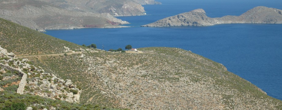
•1 LIVADIA – DESPOTI NERO – AG. PAVLOS – LIVADIA (my total time 5h33, includes stops for photography, a few short rests and a couple of swims in the ocean – net walking time was about 3h40; +-522m; 2 laps): This is walk 43 in the 1st edition of /Graf/, 49 in the 2nd. A great walk that has my warmest recommendations. You must absolutely do this walk if you are on Tilos.
Just follow the book, or use the blue map. This path is easy to find and mostly easy to follow. Waymarks are also mostly good, but you should VERY carefully follow these down towards Despoti Nero, the path is overgrown and almost nonexistent at this point. Also mind that to reach the beach you will have to cross a scree area a hundred meters or so wide. /Graf/ has no mention of this. A modicum of care has to be taken here.
The last part down to Ag. Pavlos is very steep, very rough and without any path or waymarks. Only recommended for experienced and confident walkers. If you are not one of these you should instead continue on the dirt road from the previous saddle.
•2 LIVADIA – THOLOS – LIVADIA (basic duration about 4 hours): A variation of walk 1 above. Skip Despoti Nero and continue as directly you can towards Tholos on dirt track and (eventually) metalled road. Return along dirt tracks directly to Livadia. Use the blue map, the route should still be easy to find and follow.
OBS: I did this walk last in 1997!
•3 LIVADIA – LETHRA – MIKRO HORIO – LIVADIA (my total time 3h23, includes stops for photography, some sightseeing and a swim in the ocean – net walking time was about 2h15; +-383m; 2 laps): This is walk 42 in the 1st edition of /Graf/, 48 in the 2nd, but in reverse. I think the walk is easier to find and follow in this direction.
If you follow the direction from the book just be aware that at least on my last visit the initial trail had been rerouted because of a cave-in (From the taverna “Omonóia”, which is technically also not a taverna but a kafeneion). Instead walk along the road until a sharp left bend where you will clearly see new waymarks appearing.
From “my” side the ravine is very easy to access, and the route is now well marked and also a distinct path has developed. So unlike when I was first here in 1997…
Out of the ravine, just follow the dirt road. Cross the main road and continue on your favorite goat traces until you bump into (from your left hand side) an old stone “road” (or almost, in places…) that will take you up and directly into the old ghost town.
Down again from Mikro Horio you can just stroll along the dirt road, then fork left twice and look for waymarks again on your right hand side (a chapel is on your left).
•4 MEGALO HORIO – ERISTOS (duration 20 minutes of fast walking): Use the map and pick whatever road, dirt track or path you like!
•5 MEGALO HORIO – CASTLE – MEGALO HORIO (duration ?): I did not do it. Is it worth the effort? There are reportedly only outer walls left…
Two walkers tried out these walks in the summer of 2001:
• Livadia – Mikro Horio – Lethra – Amokhosti – Livadia: We encountered some problems in finding the descent to Lethra Beach from Mikro Horio. The point of departure from the main road is not obvious. We had to ask our way. Even so, choosing the right side of the ravine was difficult enough, and it took some time before we ended up the right place. The right thing to do is to start on the right hand side of the ravine. We descended from Mikro Horio to the road by taking the opposite path/stairs than the dirt road from the main road to Mikro Horio. When you reach the road from the path, make sure you turn right on the main road, and follow it for about 15 minutes before a 5 minutes walk on a dirt road on the left takes you to the ravine. Albeit that it is easier to find the path from Lethra/Amokhosti beach, we certainly can recommend to reverse the trip, as we did. You will get a magnificent view of the sea when descending through the ravine and walking back to Livadia.
• Livadia – Agios Ioannis – Despoti Nero: A nice alternative to Tholos is the Despoti Nero beach. The Despoti Nero is actually a source, but the beach is pretty close. You will almost be certain to have the beach for yourself. However, you will need a good pair of boots, as the hills are stony and steep. Bring enough water. No shelter from the sun is offered on the entire trip. Finding the place is easy: just follow the road along the beach in Livadia to the opposite end, take the ascending road to the right, then take the path further and start descending to the left where you see a smaller path. Bring along the Nisos Tilos map.
• Good starting points: • Livadia – most walks starts from here, bus to Megalo Horio • Megalo Horio – some (less interesting?) walks starts here
• How to get there: • By ferry or catamaran from some islands
• More info: • Tilos – Home – Tilos Municipality website
This page was last modified at March 1, 2026.
©1997-2026 .