MALTA
Malta is in fact the most densely populated area in Europe, and it may come as a surprise that this little island is at all interesting for walking. But it is, and you can do very nice city walks as well as coastal walks with quite dramatic views. And the much quieter islands of Gozo (an excellent walking destination in its own right) and Comino are within easy reach for day trips. The island does have its annoyances, though. Firstly, all the bird shooters spoil any chance of having peaceful walks in the more remote areas during weekends, secondly it seems that even the smallest jeep track is covered with asphalt (or remains there-of…). Apart from its characteristically undulating hills carrying their towns and huge churches, the most sympathetic feature of the island is its incredibly mild climate, offering great swimming at least through November.
The walks below are from two trips to the island, the first from 2001, the second from 2004.
– 2001 –
Selected walks: For walks on Malta take a look in Douglas Lockhart’s “Landscapes of Malta, Gozo and Comino”. All references below are to this book, as “/Lockhart/“. You should also check out “Walking in Malta” by Paddy Dillon and Malta: 10 Great Walks by Emmet McMahon and Jonathan Henwood. PLEASE NOTE: When I refer to walk numbers etc. in /Lockhart/ below the references are all to the 3rd edition of the book.
UPDATE: For owners of the 4th edition of /Lockhart/, where I have any comments at all I have included notes after each walk. All the walk numbers are still the same. Beware that these notes are not quality-tested in any way, but are made from my assumptions.
UPDATE 2: I hope the latest 5th edition of /Lockhart/ makes most of my objections below unnecessary.
•1 VALETTA (a stroll of about 1h): This is walk 1 in /Lockhart/. No chance of getting lost here. A very short walk in itself, but many diversions are possible under way, like visiting museums and churches. Excellent views, especially of the Grand Harbour.
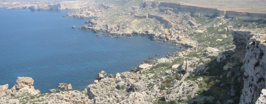
•2 RABAT TO MĠARR VIA THE COAST (net walking time 4h03): This is walk 12 in /Lockhart/. Few difficulties en route, nice views, but should maybe be avoided in the weekend, there will be painfully many bird shooters around.
Out of Rabat (from Busugrilla), the instructions in the text are a little misleading (the map is correct). It says “turn left on a narrow road”, but actually you continue STRAIGHT AHEAD as the road bends right. Also “25 minutes from Mtahleb, bear left” felt a little off when again you continue STRAIGHT AHEAD where a road forks off left. In Bahrija I could not see any house named “New Ark”, but you pass to the left of a cafe/bar called “New Life”… Later, on the first cliff top: I have no idea what a “pillbox” means in this context, but you have a concrete hut below you on the left, which you first pass, then almost immediately you fork off sharp left and walk back on the upper side of the hut once again. Take care to find this narrow path, if you continue straight ahead here you will almost immediately be in the range of some of those shootists.
After the Fomm ir-Rih Bay, when you pass the last house, all further progress up the hill is barred by “Private” signs. It seems best at this point to continue on the concrete track that take off left from the continuation of the road to your right. The concrete track is barred with a metal chain and more “Private” signs, but this is the only way you can get BETWEEN the shooters’ huts. Continuing straight along the cliff edge seems to take you straight into their range and may be very unwise. When the track ends, stroll over land until you can pick up the path again and turn right. Again, be sure to spot, finally, the narrow path left down the cliff. But be patient, there are several cracks in the cliff edge where you are NOT supposed to enter.
UPDATE: In the fourth edition all the main issues I have noted above seems to have been well dealt with. Good job!
•3 MOSTA – FALKA – XEMXIJA VIA THE CHADWICK LAKES, THE DWEJRA LINES AND PWALES VALLEY (net walking time 4h26): This is walk 13 (cutting off the bit from Falka back to Mosta) followed by Walk 9 (Alternative walk) in /Lockhart/.
Most of the first walk is very easy to find and follow, it is only when you leave the Lines themselves that some problems arise. Getting yourself from the Lines down to Falka is in fact EXACTLY as described in the text, but the “footpath (with the Lines on your right)” is obscured by debris and litter. You will have to step through this mess before you are able to see the path.
After the Falka Pumping Station (notice the small sign on the gate!), the track “turns right just before a ruined hut and a vineyard”. The text does not tell that you are actually supposed to CONTINUE STRAIGHT AHEAD at this fork (again the map is correct). Happily I got directions confirmed by a man on horseback passing me just here. It does not get any better in Bidnija. There are AT LEAST three interpretations of which road you should follow from here. FIVE roads meets close to the church. Counting clockwise from and including the road straight ahead (later left) from where you enter Bidnija, you should take the THIRD, which is about a 90 degrees turn right. Walk 8 comes in from the other side of the church, which means that a right turn for Walk 8 is still a right for you. You are supposed to follow walk 8 from here.
At the “club-house” the track turns left AFTER it has passed the houses. A bit after the fireworks factory the path has been bulldozed, but the going is still obvious, more or less straight ahead by the wall. Most of the rest of the walk is very easy to follow, as a large portion of it is road-walking.
UPDATE: In the fourth edition all this is clearer. I would still have loved that all five streets that meet in the center of Bidnija was indicated on the map, but that is nit-picking, as the necessary street names are given. Again an excellent job!
– 2004 –
Selected walks: For these walks see Douglas Lockhart’s “Landscapes of Malta, Gozo and Comino”, referred to below as “/Lockhart/“, and the now out of print “Malta & Gozo Walking Guides” by D. A. Brawn, referred to below as “/Brawn/“. You should also check out “Walking in Malta” by Paddy Dillon and Malta: 10 Great Walks by Emmet McMahon and Jonathan Henwood. PLEASE NOTE: When I refer to walk numbers etc. in /Lockhart/ the references are all to the 4th edition of the book.
UPDATE 2: I hope the latest 5th edition of /Lockhart/ makes most of my objections below unnecessary.
•4 BUĠIBBA – GĦARGĦUR – ST. JULIANS (my total time 3h27, includes only short stops for photography; +294m -287m, 1 lap): This is (most of) walk 2 in /Brawn/, but in reverse, followed by walk 7. Not a truly great walk, but some very interesting bits on the last part (walk 7).
My timings start at the HBSC bank in the Bay Square. From here you must carefully weave our way out of Buġibba to get to the starting (ending really) point of walk 2 on Kennedy Drive. Easy actually, even the map in the Lonely Planet guide will do.
Now you must start to reverse the instructions for walk 1, but this is not overly difficult, the text is very detailed. After the “old donkey trail” remember to turn left on the road. The “locked barrier” is to your immediate right here.
By the viewing point (with the statue) just above the Victoria lines (the starting point for walk 5 I think, and where walk 4 starts really walking the lines), you leave walk 2 and turn left towards the quarries to curve into Għargħur from below. This road is clearly marked on the map (as “walk 5”).
From Għargħur follow the instructions for walk 7 CAREFULLY. The text is correct at all points and you should read it all before you progress any further, to keep surprises away. Mind that some parts are difficult, and some are a bit overgrown. But big fun!
The correct path down the wied after the “vandalised house” is difficult to find. There are so many to choose from. It went well for a while, but trying to follow the “main” path at all points (usually a good trick!) did not pay off for the last leg. Probably, at the bird trappings area, “right and left” in the text must be taken quite literally, as “right and THEN left”? I ended up crossing the wied to far up, and had to do some road-walking on the other side to get in direction to the bay again.
•5 GĦADIRA – POPEYE VILLAGE – GĦAJN TUFFIEĦA – MĠARR (my total time 3h50, includes only short stops for photography; +318m -218m, 1 lap): This is walk 6 in /Lockhart/, followed by (half of) walk 12 in /Brawn/. Incredible landscapes and sights all around.
Never very difficult to follow this walk, although the text should be read carefully. But how to start off? The police station in Għadira is not difficult to find, but what next??? The text is confused here, you take LEFT at the police station (to follow the mentioned signs), then IMMEDIATELY right just after the wall.
Towards Golden Bay the approach in the text is NOT the one shown on the map. When you finally pass the signed entrance road into Golden Bay, just continue towards Għajn Tuffieħa and Għajn Tuffieħa Bay instead, it is much more interesting, and only 100m away.
From Għajn Tuffieħa Bay follow walk 12 in /Brawn/ to Mġarr. I can recommend the “difficult” route, but beware, a meter or so of the vertiginous path around to the right side of the cliff has caved in and slid down to the sea. Be very careful so you don’t do the same. If this gap looks impassable when you visit, please turn back and do the easy route instead.
•6 COSPICUA, SENGLEA AND VITTORIOSA (my total time 1h40, includes only short stops for photography; +-124m, 0 laps): This is walk 2 in /Lockhart/. An even nicer city walk than Valetta (Walk 1 above).
Even here you must read the text carefully as it is a bit difficult to understand where to go first just from the map when most points are passed both to and from the various sights. Better use of arrows would have made the map more readable.
On my visit the Fort St Angelo was closed to the public.
•7 MDINA AND RABAT (my total time 0h58, includes only short stops for photography; +-25m, 0 laps): This is walk 3 in /Lockhart/.
You should have few difficulties on this walk, but even here you must carefully read the text (many times a bit unclear) AND compare it to the map to find the correct way.
On my visit a festival was going on in Rabat, and the San Pawl street was impassable for a shorter stretch. It did probably cost 5 mins extra or so to walk around this and get back on track.
• Good starting points: • Valetta and surroundings, e.g Sliema – from here buses will take you around the entire island • Gozo – thanks to the excellent ferry and bus connections you can in fact do all walks on Malta from a base on this more quiet island if you want to
• How to get there: • By air
• More info: • malta.com • Nature in Malta
This page was last modified at March 9, 2026.
©2001-2026