SÃO MIGUEL – The Azores
The Azores (Northwest of Madeira) are an entire archipelago with many different islands widely spread. For now I only have any information about São Miguel. This is the biggest and most populated of the islands and hence where it is most easy to get around by local bus. Extremely green and fertile, with relatively few tourists even on this “main” island. Makes one wonder what other gems may be hidden in the Atlantic ocean around these parts… The walks on this particular island are of such a pleasant category that hardly nowhere is such beauty and peacefulness so easily available and so little struggle needed to move around in.
Best restaurant in town? If you ask me “restaurante barcarola” at Largo da Matriz, 16. This is just left of the big church you can see on the picture above. A surprisingly elegant and modern place with minimalistic decor. UPDATE: Sorry to disappoint you, but reports now say that this restaurant just closed down.
Selected walks on São Miguel: For walks on São Miguel see “Landscapes of The Azores” by Andreas Stieglitz and “Azores” by David Sayers. These books are referred to below as “/Stieglitz/” and “/Sayers/”, respectively. There is also “Azores” by Hannelore Schmitz. When it comes to the Sunflower guide this one is actually one of the absolute best I have used, even compared to their usually high standards. All the walks were very easy to follow, and I have nothing of real importance to add. Where I have found a few details that may be slightly wrong as of my visit I have made a note of that below. AND PLEASE NOTE: when I refer to walk numbers etc. from this book they are all taken from the 2nd edition. There is now already a 4th edition of the book, and the details could likely have changed.
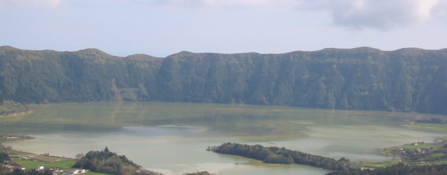
•1 SETE CITADES – VISTA DO REI – JOÃO BOM (my total time 4h05, includes short stops for photography and snacks; +532m -553m, 2 laps): This is walk 2 in /Stieglitz/. A fantastic walk! What beauty! What scenery! Still the whole walk is rather easy. But some tree fall and mudslides to be negotiated on the ascent make boots preferable.
At 4h05 in the book the fork is 20m after the cattle trough. Shortly before 4h35 “meet the bend of an asphalt road”, this is the second road you meet. Also note that the bus surprisingly enough leaves in the direction of (down into) João Bom, where it takes this minor asphalt road north towards the next village.
•2 FURNAS – LAGOA DAS FURNAS – PARQUE TERRA NOSTRA – CALDEIRAS DAS FURNAS – FURNAS (my total time 4h22, 3h20 excluding the park, includes short stops for photography and snacks; +-217m, 2 laps): This is walk 5 in /Stieglitz/. The park has a 3€ entrance fee. I used around an hour here, this is an absolute minimum. A very beautiful stroll.
Mind that the main crossroads in Furnas (just before the bus stop) is a little misleading on the map in /Stieglitz/. The four roads does not meet at the same point, the road towards Caldeiras das Furnas leaves from around twenty meters north of the others (compare the map to the text). In effect this is a staggered crossroads. Also mind that buses in all directions goes in towards the bus shelter (and stops on the other side of the road, by the Parada sign), before turning around and leaving via the same (set of) crossroads.
•3 JOÃO BOM – RABO DO ASNO (my total time 3h47, includes short stops for photography and snacks; +478m -606m, 3 laps): This is walk 1 in /Stieglitz/ (Alternative walk 1). A nice (but somewhat long) stroll, or a useful walk for stretching your legs a little. You can glimpse some good coastal landscapes from the partly sunken track.
•4 ÁGUA DE ALTO – LAGOA DO FOGO – BAHIA DA PRAIA (my total time 4h41, includes short stops for photography and a picnic; +666m -719m, 2 laps): This is walk 4 in /Stieglitz/. Another extremely beautiful walk, this time to what might be nicknamed (in my mind anyway) “Lake Fog”. Lots of weird nature to admire!
The bus information in /Stieglitz/ is slightly wrong. The “village sign” is not for “Praia” but for “Água de Alto”. Also I can see no reason to buy a ticket for “Villa Franca” anymore. A ticket for Água de Alto is 2€, and Villa Franca is 2€35.
Just before the lake, the second “wooden gate” is now missing.
•5 PONTA DELGADA CITY WALK (my total time 1h24 excluding museum or other visits; +-32m, 0 laps): This is the “Town Trail” from /Sayers/. A nice and interesting little stroll, best left for a Saturday afternoon (if you would like to visit the mentioned museum) or a Sunday. Beware that the map tracing of the walk is wrong at points, and that the street names mentioned in the text are actually wrong on at least one occasion… Still you cannot go very wrong here.
• Good starting points: • Ponta Delgada – from here bus will take you around
• How to get there: • By air • By ferry from some other of the Azores
• More info: Sorry, none yet
This page was last modified at March 9, 2026.
©2003-2026 .