Αμοργός – Cyclades
When it comes to picturesque mountainscapes and hill villages (especially the Hora), as well as great walking, Amorgos is at the top of the shelf. At least out of high season it is very nice and quiet, and the small beaches quite sufficient. Whatever you do here, it is no way you can dislike this island.
The main port at Katapola has the most to offer when it comes to accommodation and tavernas, and is a nicely situated town, below the hill of Minoa. The resort of Egiali (or Ormos) up in the north is even quieter, a surprisingly peaceful little gem of a town, surrounded by an even more dramatic landscape than Katapola. I am lost for words when it comes to the Hora. It just must be experienced!
Selected walks: For walks on Amorgos take a look in “Trekking in Greece” by Marc Dubin (referred to below as “/Dubin/”), “Walking the Aegean Islands” by Dieter Graf (referred to below as “/Graf/”) or his newer “Amorgos, Naxos, Paros and the Eastern & Northern Cyclades” (referred to below as “/Graf2/”), which is more up-to-date. Even “Greek Island Hopping” by Frewin Poffley lists the major walks and has a small map. A newer book Amorgos – A Walker’s & Visitor’s Guide by Paul and Henrietta Delahunt-Rimmer looks very interesting. On the web visit Walking, hiking and trekking on AMORGOS by Raymond Verdoolaege. A new and updated Anavasi (1:32000) map now exists and I can only recommend this one warmly. I only had an old walking map (by Dr. Georg Perreiter) that used to be on sale just about everywhere on the island but that one has not been updated for a very long time and must be considered completely outdated by now.
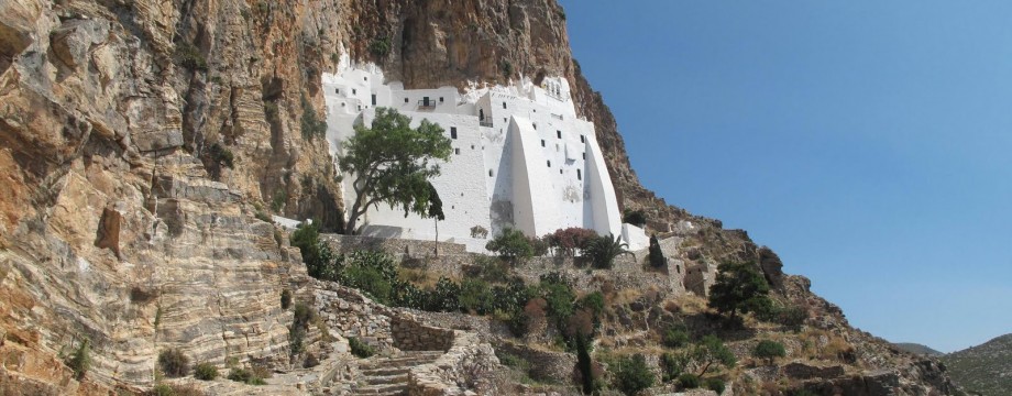
•1 Katapola – Hora – Ag. Ilias – Moni Hosoviotissa – Hora – Ag. Georgios Valsamitis – Stavros – Katapola (6h14 walking time, add time for sightseeing at the Monastery, sightseeing and lunch in Hora and sightseeing at Minoa etc.): This is a combination of walks 2 and 3 in /Graf/ (or 8 and 6 in /Graf2/), and takes in the best of the island in just one day! For experienced walkers only.
The instructions in the book(s) for finding the path to Hora is unnecessarily complicated, why not follow the clearly sign-posted route up from the waterfront instead? The idea is to avoid the town refuse dump, but you cannot help seeing it anyway, as you will eventually enter its upper corner to find the monopathi leading upwards. If you do take the initial route described in /Graf/, remember to turn left when you hit the first dirt road. This is far to vague in the text, but see the map! If you instead just continue ahead (rightish) there will be another dirt road after just a few meters, and when you turn left here you are again on the dreaded sign-posted route, that goes via the refuse dump.
When you hit the road below Hora, skip the instructions in the book and instead turn left to curve around the village. Continue at first past the aerial above town, then turn down left by the bus turning point for a viewpoint and have a look. Great huh? But it will get much better! Leave the Hora for now, you will return to this exact spot later, instead pick up the instructions for Walk 3, by walking back past the aerial and picking up the path on its left side.
The path around Ag. Ilias will eventually dissolve, and you will just have to use your best judgment here. I did not find the ideal route. The green arrows pointing up towards were easily spotted, but there were no red dots straight ahead at my visit. But a field on a plateau can be seen and continuing slightly downwards to this (if this is indeed the one mentioned in the text) and picking up a path between walls heading for its lower left side, will eventually allow you to curve around it to the right (do not enter the field via the gate). Continue to follow the wall back down on the other side until the rocks are low enough to climb. On top of this small ridge all paths again dissolves. Further on paths again materializes, but unfortunately there must be several, as the one I found headed for the main road too early, and I had to hit the road a couple of wide turns before I really should. I could see the other path coming down the hillside later. It is very difficult to navigate here, because the old electricity lines that is mentioned in the text, and which is more or less essential to find the right height for curving around the mountain, have now been taken down! Hopefully the newer instructions in /Graf2/ can shed more light on the current situation and be easier to follow.
Eventually you should have found your way to the saddle where you can cross the dramatic mountain ridge. Skip the instructions in the text here, because it is not at all necessary to go down to any of the roads that scars the landscape here! Instead turn right and slowly and insecurely (sorry) make your way down goat traces before a better path comes in left. This in its turn will take you slowly and more securely down towards the main path, which it hits just before the animal sheds, by a crossroads with a signpost, one arrow pointing left towards Egiali, another pointing back up from where you came. The colour of the sea as seen from up these hillsides is the most fantastic shades of azure I have ever seen!
Down towards the Monastery the path is very “entertaining”. At a couple of points just past the scree area, most of it had disappeared down into the sea. Not good for those suffering from vertigo.
At the other side of the monastery you will see another sign-posted monopathi back up to Hora, and you are soon back at the bus turning, where you enter the town via its main street. Soon you will get to the post office, where you find the continuing route of Walk 2 to the left, just before the telephone box. But before continuing stroll past the post office to find an extremely tempting café (or more).
The rest of walk 2 is easy to follow, just read the text carefully and you should not go wrong.
•2 Hora – Egiali (via Terlaki if you are a true masochist) (my total time 5h30, including a short breakfast en route): This is Trek 1 under “NORTH-EAST AMORGOS” in /Dubin/, using the suggested inland alternative “valley route” via Terlaki (for access from Hora, see the parenthesis under “Link Trail” on the previous page). Unfortunately, without an updated map, the going became very tough on this walk.
At it were, I found some parts of the trail to be nice, some parts to be turned into roads, some newly destroyed by bulldozers and finally some totally overgrown. More investigation could be fruitful, though, especially with an updated map. If you feel inclined, here are the instructions:
First pack an additional map (Unfortunately I only had the Perreiter map at the time, with the new and updated Anavasi map I think this walk would have been much different experience…), a compass and an altitude meter! Where the path down to Katapola turns down left from Hora, pick up the steep path downwards to the right. Down the first hillside and up the next the monopathi is good fun, and there is not much doubt about directions. On top of the hill again you meet a dusty road, the path is long gone here. Follow the road past Terlaki, then leave it to the left on a newly bulldozed track when it swings sharply upwards to the right. The destruction of old paths never seem to stop! Where the bulldozer had left (for now!) the path continues on. First it goes down into a narrow ravine, then steeply up on the other side. On the top are some sheep pens. Maybe a dog on the loose here!
After the pens a continuing path of some sort take you down into a small valley and up the next hillside where it seemed to just dissolve into animal traces. Vegetation increases, and soon you are pretty stuck in a maze of thorny bushes in yet another small valley. Not good without long trousers. It is soon over, but progress will be very slow. On the opposite side of the valley you can see a path materializing more or less in the direction of a small well kept chapel. The path to that chapel is your goal, and you must at all times keep track of the chapel and the path as you patiently cross the maze towards it! Even if I could not see it, it is quite possible that this path could start somewhere from the previous ridge, thus making the arduous task of crossing the valley much easier. I did not take the time to investigate, so when I eventually got to the path I followed it LEFT towards the chapel.
At the chapel a good path takes off right. You follow this path first on the level, then down into the next valley. Then walk up this valley encountering a shady picnic spot at the valley bottom. Go through some gates and get yourself towards a house that you will have seen some time ago from the distance. You should also have seen clearly that this house has a road winding down towards it. This road (more gates) takes you up to the main road just after the saddle encountered in walk 1 above. Cross the road and pick up the dusty road up and left, towards the next saddle, where the sign-posted and excellently waymarked main path continues to the left of the next hill. From here it’s plain sailing, and there is hardly any need to refer any book or map at any point.
• Good starting points: • Katapola – buses to most destinations on the island, and some walks can be done right out of town • Egiali – some buses to hill villages, and some walks can be done right out of town
• How to get there: • Almost daily ferry from Naxos and the Smaller Cyclades (depending on season) • Some ferries from other islands • Some ferries from the mainland
• More info: • Walking, hiking and trekking on AMORGOS by Raymond Verdoolaege
This page was last modified at February 17, 2026.
©2001-2026 .