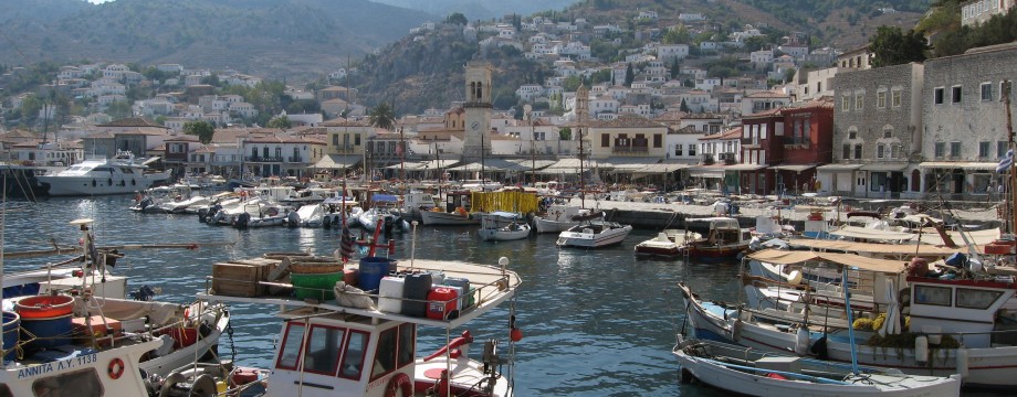
΄Υδρα – Argo-Saronic
Can you imagine what a Greek Island (or the world for that matter) would have been like without cars? Well, wonderful, if you ask me. And here is the proof, because cars are in fact banned from Hydra. No idiots on motorbikes either, because (you guessed it) there are no motorbikes! There are a couple of trucks (including a garbage truck) in town, but other than that land transport all over the island is done by donkeys etc. This also means that all the old donkey trails that are so great for walking are also perfectly maintained, as they are in daily use. Perfect! This has given the island an exclusive and expensive reputation that at least in part is well deserved, but it is all well worth it.
Selected walks: For walks on Hydra take a look at HYDRA: DONKEY TRAILS, MONASTERIES, AND THE SEA THE SEA (sic) by Janet McGiffin, referred to below as /McGiffin/. A good Anavasi (1:25000) hiking map exists (see above), referred to below as /Anavasi/. Mine is a bit too old (2007 edition), beware that on editions that old some of the route tracing is slightly off at points, and even important links missing. An updated version (with more walks, now 5 “official” hiking routes that are also signposted in yellow) is posted in the harbour, where also the yellow walking signs start.
•1 HYDRA TOWN – EPISKOPI (+ RETURN) (my total time 3h36; 589a 596d; net walking time 3h21, note that no extra time for photography or longer rests is included in the total time as it was rain in the air): This is hike #3 in /McGiffin/, walk #2 in /Anavasi/.
The walk is easy to find and follow, except that more detail needed than is provided by /McGiffin/ at Kamínia. “Pick your way around the beached fishing boats…”. Walk down to the small harbour and ascend the concrete stairway at the other side. On top of the few stairs the path onwards begins.
On your way back you can use the “delightful return” in /McGiffin/ (see picture above) straight back to town (I think, keeping right) or down left to Kamínia again (as I did).
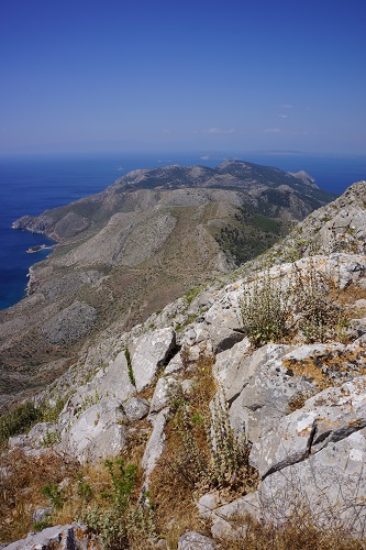
•2 MT. ÉRES (my total time 3h26; 711a 707d; net walking time 2h48): This is walk #1 in /Anavasi/, a variation of hike #1 in /McGiffin/.
An absolutely wonderful walk, with extensive views. And not too tough, especially if you follow the shortest, most direct route.
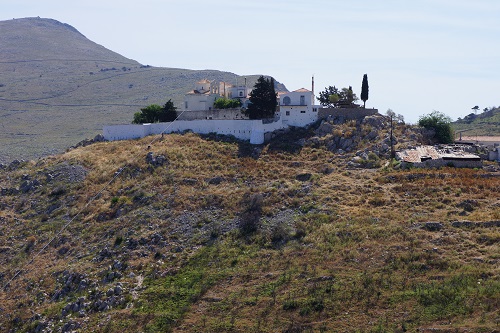
Basically disregard all instructions given, they are not needed, or even confusing. Just follow the official marking (also red or orange dots and arrows). The only place you need to be aware is where the stone trail eventually forks into Profitis Ilias (left) and St. Efpraxia + Profitis Ilias (right). If you have no intention of spending time at the monastery go RIGHT here. At St. Efpraxia go through a wide gate and in a few meters take the path out LEFT (to Profitis Ilias again), but almost immediately fork right on the signposted path to “Mt. Eros”.
•3 HYDRA TOWN – STAVROS – MANDRAKI – HYDRA TOWN (my total time 2h38; 369a 364d; net walking time 1h49): This is walk #4 in /Anavasi/.
An easy walk in all respects, use the good map and follow waymarking where needed. The Mandraki castle might look interesting from a distance, but is actually not much to look at in reality. I will not blame you if you turn around at the pretty taverna instead.
• Good starting points: • Hydra town – most accommodation is here, walks can be done straight out of town
• How to get there: • Excellent ferry/hydrofoil connections from Piraeus’ Great Harbour
• More info: • HYDRA: DONKEY TRAILS, MONASTERIES, AND THE SEA THE SEA
This page was last modified at February 19, 2026.
©2007-2026 .