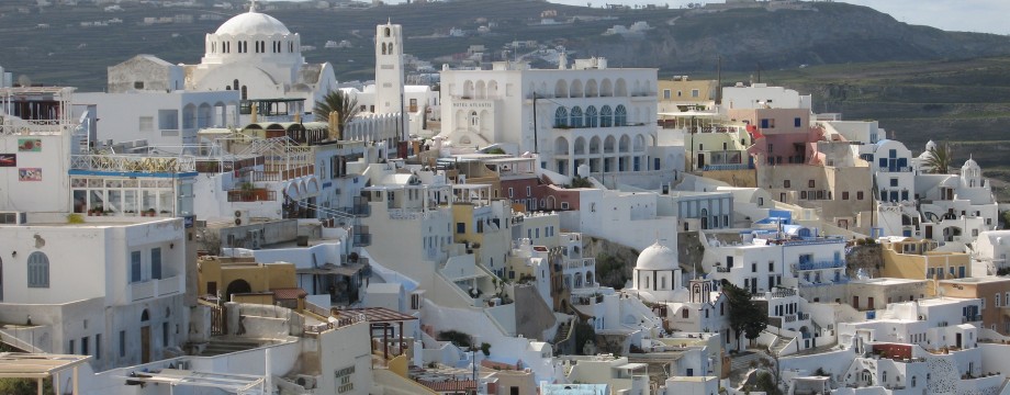
Θήρα – Cyclades
The island that everyone “must” visit… This includes a countless number of cruise ships, which pour their “cargo” out into the small port below Firá all day. This scenic island of volcanic origin has indeed a very impressive appearance, and the views are spectacular. It is even claimed that 90% of the postcard pictures from the Greek islands are from this particular island. The reason is quite obvious. But over-priced and over-hyped it still is.
Its popularity makes all really interesting places to stay extremely expensive, and the island should be avoided any time near high season. Most hotels open in April, and some of the better ones are open all year. At these times you also pay more reasonable prices. A much better choice! But bring warm clothes, this island gets very windy, and both night and day can feel horribly cold, even if the actual air temperature is not so bad.
With its airport, Santorini can at least be used as a springboard to other less touristed Cycladic islands. You will get a good impression by taking the ferry through that volcanic crater anyway. And by taking the bus from the airport over the lowest part of the crater wall and down to the main port. Some ride!
The island is a producer of some really excellent wines (Santo Wines’ Assyrtico is in fact one of my favorite white wines), grown in its special volcanic soil. Unfortunately it seems in Greece the better the wine region, the worse stuff you are served at local tavernas. Not that the wine is bad in the first place, it is destroyed on the way from the producer to the consumer. Sad! In season you can find just about anything on Santorini (at a price), but if you prefer home-made Greek fare, the situation is ridiculous. The supposedly “best” traditional restaurants (recommended both by guide books as well as locals) I can only warn about. Absolutely pathetic. The much simpler Parea is ok, and the extremely cheerful and friendly Elia (The “olive tree” restaurant) has my warmest recommendations. But to avoid disaster, buy your wine at the merchants (or supermarket), and drink beer (or Ouzo) with your dinner! I have now taken a wow not to drink wine in a Greek taverna again, but stick to beer (which is so excellent with Greek food anyway). The exception to my rule is BOTTLED Retsina, of course…
Selected walks: For walks on Santorini take a look in “Santorini, Sifnos and the Western & Southern Cyclades”, referred to below as “/Graf/”. On the web visit Walking, hiking and trekking on SANTORINI by Raymond Verdoolaege, referred to below as “/Verdoolaege/”. Good Anavasi (1:40000) and Road Editions (1:35000) maps exist. Both indicate the most important footpaths, and the Anavasi one even has a small hiking guide printed on the back.
•1 FIRÁ – OLD PORT – FIRÁ (my total time 1h11, includes short stops for photography; +-239m, 1 lap): Just a short stroll. Follow street signs to “Old Port”. Take some care, the donkey steps might be very slippery after rain.
•2 FIRÁ – OÍA (my total time 3h20, includes short stops for photography; +602m -715m, 3 laps): This is walk 1 in /Graf/. The book gives a very broad description about the actual route, so you might want to refer to /Verdoolaege/ for more (maybe even too much) details!
Fantastic walk, and it is pretty easy to find your way. The route is mostly obvious “straight” (or as straight as possible) ahead.
Just before the desalination plant in Oía new development disturbs (April 2008) the old track by covering it with truck loads of rock and building debris. Just climb any such mess you should encounter, and continue steadfast ahead!
You pass the desalination plant itself on the right hand side.
•3 OÍA – FIRÁ (my total time 5h, includes short stops for photography and drinking, as well as a couple of longer rests; +598m -482m, 2 laps): This is walk 2 in /Graf/. Its first part is also mentioned in /Verdoolaege/.
Starting opposite the “Market Oía” was a surprise difficulty as the shop was closed and all signs gone! But it is the building you pass to the left of when the track followed in the walk above ends.
The track you follow soon splits up, and you should NOT go left into a private orchard. The map tracing in /Graf/ seems to indicate that you should follow the creek at all times, but this looked very overgrown (in spring). The text in the book also seems to contradict this. Continuing on a footpath on fields covered with flowers made for a nicer walk, but a huge curve around vineyards was necessary, and probably a detour from the intended route. Well, I started at the right location and ended up at the right location, finally picking up the dirt track mentioned in the book, so it could not be all bad.
Towards the windmills/holiday homes, I doubt if they remain “unfinished” for much longer, you might very well soon be trespassing crossing between them as indicated in the book. And pick your way carefully, it is stony and steep here. But an exhilarating climb it is! Animal traces make the going easier.
Above the main road there was no “well worn trail”, but just continue as previously for another short while.
•4 AKROTÍRI CIRCULAR (my total time 1h59, includes short stops for photography, a small rest and some “investigations”; +-340m, 1 lap): This is walk 8 in /Graf/. Presently (April 2008), the Akrotíri excavations are closed, and they will remain so for now. It is very uncertain if the site will open for the public at all this season. Luckily there are still sufficient buses to enable you to do this nice little walk. The Akrotíri village itself is also delightful.
This easy walk is almost just a stroll. From the start disregard the instructions in /Graf/ and just walk the road up to the bus stop in the Akrotíri village. The track starting at the memorial only goes to private ground, and you will be TRESPASSING here! (Hint: Gate, mail box, bell…)
Towards Kambia Beach the track you are walking divides into three. There is no indication in the book where to go. The middle option heads for the sea, but there are obviously huge cliffs you will have to scale later, and there is nothing in view at this point telling you that this is even possible. But if you do follow the beach it should not be a big problem climbing the fairly steep hillside when needed to find the good footpath above. Another option is to leave this rather uninteresting beach and take the left option at the crossroads (towards a chapel). You can cross the fields here (do not ascend or descend much, just curve around the hillside) and pick up the mentioned path.
At the Red Beach you climb (easily) a huge scree covering most of its last part to get to the cliff above. Then it is down again on the other side to find the road along the shore.
• Good starting points: • Firá – good bus connections all over the island (see below)
• How to get there: • By air • By ferry from other islands, mainly other islands in the Central Cyclades as well as Crete • By ferry from the mainland
• More info: • Walking, hiking and trekking on SANTORINI by Raymond Verdoolaege • Santorini’s Buses by KTEL Santorini
This page was last modified at February 27, 2026.
©1997-2026 .