Σύρος – Cyclades
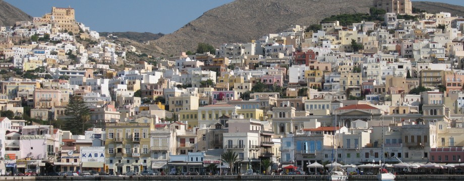
Syros town (or Ermoúpolis) is a grand city and reason enough to visit the island. Ok, it is a bit noisy? Perhaps. It got its fair share of morons on motorbikes? Certainly. But still it is an absolute must! And there are no problems finding walks to do too either. Even some walkers’ signs exist here and there.
Selected walks: For walks on Syros take a look in “Walking the Aegean Islands” by Dieter Graf (referred to below as /Graf/) or his newer “Amorgos, Naxos, Paros and the Eastern & Northern Cyclades” (referred to below as /Graf2/), which is more up-to-date. A good Anavasi (1:20000) map exists.
•1 ERMOÚPOLIS – PLATI VOUNI – ERMOÚPOLIS (my total time 4h28 includes stops for photography, drinking and lots of exploration; +-811m, 3 laps): This was intended to be walk 46 in /Graf/, but the text was out-dated and more or less impossible to follow. Hopefully you will be more in luck with trying walk 44 in /Graf2/.
/Graf2/ still insists that you “bear left at the end of the beautiful stairway”. No, the stair street continues. Bear left one block before the end. There is actually no turn left at the top, there the street only continues to the right…
After that all goes wrong. /Graf2/ has more detail than /Graf/, but I cannot say if it helps any. For this part of the walk I think it is better to try to explain the general idea here. What you are supposed to do is to scale the first (smaller) town hill about half way, round it clockwise, then go slightly down to cross the main road, then up the other (larger) hill, round it too clockwise (probably?), then go down again on the other side, to the “serpentine road” and the gorge. Exactly why it is interesting to do this just so complicated beats me. Remember the walker’s signs I told you about? There are several official routes here and the foot route to Ano Síros is even shown on the Chóra map in Frewin Poffley’s “Greek Island Hopping”.
The gorge is overgrown so there is no use trying that, the road mentioned in the text is what you must head for. You might even stick to the asphalt the whole way to Mitaki, since the instructions after “the wall at the end of the valley” are completely impossible to decipher. It bears little resemblance to the actual place. /Graf2/ now has completely replaced this part of the walk, also using a different route altogether.
After Ag. Georgios /Graf/ (and still /Graf2/) want you to branch off right over open ground. This is NOT advisable if you have not walked here before. Only when you have walked the “footpath” (actually a nice kalderími!) from Plati Vouni (not Plati Vouri…) and KNOW what you are looking for should you EVER try to cross this type of rough and steep terrain. At least not without better directions. Instead stay safe and stroll down the road, which soon turns into a pretty concrete road, even passing a taverna on the way. In Plati Vouni you can head for the now obvious kalderími. A long detour perhaps, but SAFE! There is also no mentionable traffic on these roads.
Back down towards Ermoúpolis new road building has changed the picture. There is updated text in /Graf2/ here.
• Good starting points: • Ermoúpolis
• How to get there: • By ferry from some islands in the Cyclades West • By ferry and speedboat from other islands in the Cyclades North • By ferry and speedboat from the mainland • By air (domestic)
• More info: Sorry, none yet
This page was last modified at March 1, 2026.
©2008-2026 .