Σκόπελος – Sporades
Skopelos will always be THE Greek island in my mind. This is where it all started back in 1994, and I still have the little glass bottle I bought in town, which I filled with water from the spring at the Moni Taxiarchon, standing in my bookshelf. Today this is a relic commemorating the birth of “IslandWalking”, although no such thing was intended at the time. The seeds were sown and watered, and three years later the first traces of IslandWalking.com started to trickle out on the web.
At my latest stop on the island I was lucky enough to stay two weeks at the cosy Mimi Rekkas’ Studio now aka “SECRET GARDEN” apartment in town.
The island is as pleasant as they come and the greenest in the entire Aegean. Well, that comes with a price, of course… Not too crowded either, even in high season. Also a good nudist spot.
Skopelos has many good beaches, the best are: Milia (more crowded after the arrival of watersports, tentatively nudist at its south end), Velanio (half of it is nudist, same half good for snorkeling) and Glisteri (pretty small, but nice and quiet, beware of sea urchins).
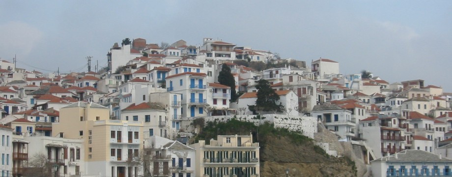
Skopelos Town is well preserved and very pretty, surprisingly unspoiled from modern development. It is in fact one of the most charming island towns among the Greek islands.
The small deserted hilltop village of Glossa also attract some interest, but if you have to choose, visit its equivalent on Alonissos instead. I personally find that one even more pleasing.
Skopelos is actually a paradise for those who enjoy easier walks in a rural or forested Greek landscape. Walking boots are not a absolutely necessity here, although on a few walks you will be better off wearing them. Be sure to pick up a copy of Skopelos Trails by Heather Parsons and the treat is all yours. On my first visit I used the old booklet “Sotos Walking Guide to Skopelos” by the same author, which is now incorporated in the new much expanded book.
Selected walks: For walks on Skopelos take a look in Skopelos Trails or the old “Sotos Walking Guide to Skopelos”, both by Heather Parsons. I refer to these books below as /Parsons2/ (2001 edition) and /Parsons1/ (1994 edition) respectively.
•1 SKOPELOS TO GLISTERI + return (my total time 1h46, includes short stops for photography; +-281m, 2 laps): By walking you can get there before the first beach boat (in summer), and the most effective way of getting to there is by Walk 2 in /Parsons1/. /Parsons2/ Walk 5 has alternative approaches, but all these routes are covered by other walks below. I prefer the original route for getting as fast as possible to the beach. An easy walk. Stroll along the (now tarmac) road towards Glisteri, and refrain from taking any side roads or paths before the valley down towards the beach at the garbage truck parking. Here take the old path/kalderimi down.
•2 GLOSSA TO AG. IOANNIS + return (my total time 4h29, includes short stops for photography and lots of investigation; +-631m, 2 laps): Walk 26 in /Parsons2/, using the tracks (and those paths that can still be found) on the outward leg, and just follows the (now tarmac) road back.
Unfortunately some of the route described in the book is now impossible, so it took a very long time to get through. The track turning right at Picture 87 now just dissolves, just continue on the road here, ignoring any forks right or left, and circle clockwise until you are finally deep inside the valley on your right. Here you will meet the track described in the book. Turn left here, and after a few meters you are at the “triangle of bushes”.
Also do not turn left on the path at Picture 85. The arrow and cairn are gone, and for a good reason. A seemingly new dirt track has been bulldozed in the valley below, and is very difficult to get safely down to (above some beehives). Instead just continue on the road and curve counterclockwise into the valley, cross it, and go left. Then you must fork left twice to stay on the upper track. Soon you will pass the beehives and get to the “water pumping station”.
•3 SKOPELOS TO SENDOUKIA + return (my total time 5h18, includes short stops for photography, short lunch, and quite some time for investigation; +-861m, 2 laps): Walk 17 in /Parsons2/, using the paths described and not the road, doing the Cypravissi Valley on the outward leg and the “main” path back. The road route is Walk 11 in /Parsons1/.
At the small church of Picture 65 follow the track just past the church, but then immediately go left/straight (instead of going out the entryway of the church) on the continuation of the path. This has been hidden by some expansion of the track at this point. There are (hidden in growth) red blobs, and I built another cairn here.
By following the marked path as closely as possible from here I (inadvertently) ended up in the Cypravissi Valley, as these where the only marks I could see. The other path (the main route) was easier to spot from the other side (Picture 67). Both these paths are pretty overgrown, and the Cypravissi Valley is a bit steep in addition.
The area by Picture 69 has been bulldozed and the rest of the calderimi destroyed. Just stay on the road.
•4 SKOPELOS TO MONI TAXIARCHON + return (my total time 4h53, includes short stops for photography and a small lunch; +-712m, 2 laps): Walk 14 in /Parsons2/, using the path by Moni Evanghelistria on the return. Without this return the route is identical to the one described under Walk 7 in /Parsons1/. Note that the duration of this walk is quoted wrongly in the Contents of the newest edition of the book (NOT 4 hours ONE WAY…). The inside of the book has the right time. An EXTREMELY pleasant walk, and a pilgrimage to the birthplace of “IslandWalking”.
Up on the road again after Sotiros: “Following the route to Prodromou until just after Ag. Barbara, …” would be more precise reading “Following the route to Prodromou until just BEFORE Prodromou, …”.
The following route is in fact a tad better described in /Parsons1/ (Walk 7), since the TWO signposts for Ag. Anna/Moni Taxiarchon now has been confused into one. Not that it matters, the route is signposted. The whole passage originally read (with my own comments in square brackets): “Eventually, when the road turns off right, wonder of wonders – in the middle of nowhere – you’ll see a signpost on a tree for St Anna’s [now it also mentions Taxiarchon]. The track starts here. It will begin to descend. Five mins later the path divides and again, another signpost! The left-hand path…”
None of the editions mention the track forking down left towards Ag. Triada some time before these signposts which you must IGNORE. Otherwise it’s a treat!
On the return, the path going down to Moni Evanghelistria is eroded and a bit steep.
•5 SKOPELOS – AG. MARINA – STAVROS – SKOPELOS (my total time 1h31, includes short stops for photography and a small lunch; +-221m, 1 lap): Walk 7 in /Parsons2/ using the original “dogless” route, which is Walk 3 in /Parsons1/. A very easy but delightful stroll. Some time after Picture 37, the path is now cut over by a newly bulldozed track. Hunt down the continuation more or less opposite.
•6 SKOPELOS TO STAFILOS AND VELANIO + return (my total time 2h39, includes short stops for photography and a small picnic; +-233m, 2 laps): The most effective way of getting to these beaches is by Walk 1 Route 3 in /Parsons2/, Walk 1 in /Parsons1/. A very easy stroll, and still not under tarmac. You will have all the information you need in the book, but it is mostly a case of continuing along the winding road, not straying out on side roads and private driveways. In addition to the spring mentioned in the book there is also one just before the beach. Over the little saddle towards the headland at Stafilos (picture above) is the path to Velanio on the other side.
•7 POTAMI (my total time 0h49, includes short stops for photography; +-73m, 1 lap): This is Walk 2 in /Parsons2/. A very easy and short stroll.
The only confusion might come from “Wiping away a tear, we turn left…”, which should read “Wiping away a tear, we turn SHARP left over the bridge…”
•8 SKOPELOS TO AGNONTAS + return (my total time 3h02, includes short stops for photography and a small picnic; +-419, 2 laps): Walk 3 in /Parsons2/, using the old footpath “in the crease of the valley” on the outward leg, just strolling along the road on the return. Walk 8 in /Parsons1/.
The signpost at Picture 13 was missing, but just continue on…
When you later hit a concrete driveway turn right to join the mentioned asphalt road.
The footpath leaving the road in the “crease of the valley” (NOT a track) is still there and paint blobs will eventually turn up. Follow these carefully. The path is narrow and overgrown, especially from the start.
After this things should be pretty obvious.
•9 SKOPELOS TO PALOUKI + return (my total time 3h56, includes short stops for photography and a small breakfast; +-635, 1 lap): A variant of Walk 15 in /Parsons2/, going by Mili village both up and down. Also described under walk 7 in /Parsons1/. The instructions for this walk can also be easily deduced from the book, and there is little chance of confusion. The going is pretty obvious at all points. The path at the goat station is easy to find, it clearly forks right from the dirt road just before. Both in the contents and in the text the total time for the walk is misleading, it should NOT read “1 way”.
•10 SKOPELOS TO DJILALI SPRING + return (my total time 2h05, includes short stops for photography; +-293m, 1 lap): This is Walk 6 in /Parsons2/.
Not far from the beginning of the walk the wooden cross in Picture 20 is now missing.
The timings for this walk seems inconsistent, also there are many (new and old) fences on the right, and I could not get a clear match for Picture 30. After about 45 mins (my pace) there is a prominent good path down right, a minute BEFORE a red painted tree where narrow traces will veer down in the same direction. The path lead more or less directly down to the spring, in about 5 MINS! Just a few meters ahead continuing from the spring is the mentioned stone hut.
•11 SKOPELOS – PROFITIS ILIAS – STATHOU SPRING – SKOPELOS (my total time 1h26, includes short stops for photography; +-158m, 1 lap): Walk 9 in /Parsons2/, returning on the Stafilos side of the hill (option 1). Again some timings seems a bit inconsistent. The time from Picture 46 to Picture 47 is no way more than about two minutes. It is the first right anyway.
After that new tracks and buildings confuse the situation, hunt out the continuing path(s) more or less straight ahead, between a couple of houses. There are few waymarks. Keeping ahead in the rather obvious direction will eventually lead to the church of Profitis Ilias.
Returning from the spring I first tried option 2, but this ran into a newly bulldozed track below a new house after a minute.
•12 SKOPELOS – DELPHI + return (my total time 5h40, includes short stops for photography, a small breakfast and lunch; +-821m, 1 lap): Walk 18 in /Parsons2/, going by Karia both ways. The original road route is described under Walk 11 in /Parsons1/. My theory was that my route would be much faster, and I guess it was, but the newly expanded road through Karia was in itself uninteresting. The “village”/scattered houses were pleasant enough though, and there was a spring. The route is very easy to follow.
•13 GLOSSA TO MAVRAGANI AND HELLENICO TOWERS + return (my total time 2h29, includes short stops for photography, and the necessary sightseeing, which was not a lot…; +-341m, 2 laps): Walk 28 in /Parsons2/, returning by the road to the Taxiarchon (north) Monastery.
Towards the first tower the timings seems both incoherent and inconsistent, but the forks left and right are correctly described, so there is no need to worry.
Both between the towers and returning from the second tower, there are more forks than described in the book, but it is all a matter of keeping ahead in the rather obvious direction.
The instruction for the return route by the monastery can be found under Walk 24 in /Parsons2/. Remember to curve left on the road by the spring at Picture 92. From the monastery I used option 1 in the book to get back to Glossa.
•14 ABUZALI CALDERIMI (my total time 1h35, includes short stops for photography; +-227m, 1 lap): This is Walk 8 in /Parsons2/. An easy walk, and not a lot to note. After the spring there are not “3 tracks”, there is only one continuing ahead. The spring was dry, maybe after all the expansion of the track that had taken place here. The second spring contained water.
Other Updates: More walks in /Parsons2/ uses paths mentioned above, and where there is now new information at hand. But please remember, I have not done these walks as such, so any new instructions may not be as “quality tested”.
• UPDATE 1: Walk 5 in /Parsons2/. The wooden cross in Picture 20 is now missing.
I have my doubts about the suggested return route Number 1. Down from Djilali spring (visited in my Walk 10 above) everything looked fenced off and locked.
• UPDATE 2: Walk 11 in /Parsons2/. “Wiping away a tear, we turn left…” should read “Wiping away a tear, we turn SHARP left over the bridge…”
• UPDATE 3: Walk 16 in /Parsons2/. “Wiping away a tear, we turn left…” should read “Wiping away a tear, we turn SHARP left over the bridge…”
At the small church of picture 65 follow the track just past the church, but then immediately go left/straight (instead of going out the entryway of the church) on the continuation of the path. This has been hidden by some expansion of the track at this point. There are (hidden in growth) red blobs, and I built another cairn here.
The area by Picture 69 has been bulldozed and the rest of the calderimi destroyed.
See also some comments about the Cypravissi Valley under WALK 3 above.
• UPDATE 4: Walk 18 in /Parsons2/. “Wiping away a tear, we turn left…” should read “Wiping away a tear, we turn SHARP left over the bridge…”
At the small church of picture 65 follow the track just past the church, but then immediately go left/straight (instead of going out the entryway of the church) on the continuation of the path. This has been hidden by some expansion of the track at this point. There are (hidden in growth) red blobs, and I built another cairn here.
The area by Picture 69 has been bulldozed and the rest of the calderimi destroyed.
See also some comments about the Cypravissi Valley under WALK 3 above.
• UPDATE 5: Walk 19 in /Parsons2/. “Wiping away a tear, we turn left…” should read “Wiping away a tear, we turn SHARP left over the bridge…”
At the small church of picture 65 follow the track just past the church, but then immediately go left/straight (instead of going out the entryway of the church) on the continuation of the path. This has been hidden by some expansion of the track at this point. There are (hidden in growth) red blobs, and I built another cairn here.
The area by Picture 69 has been bulldozed and the rest of the calderimi destroyed.
See also some comments about the Cypravissi Valley under my “WALK 3” above.
• UPDATE 6: Walk 21 in /Parsons2/. Do not turn left on the path at Picture 85. The arrow and cairn are gone, and for a good reason. A seemingly new dirt track has been bulldozed in the valley below, and is very difficult to get safely down to (above or close by some bee keeps). Instead just continue on the road and curve counterclockwise into the valley, cross it, and go left. Then you must fork left twice to stay on the upper track (second time after recrossing the valley floor). Soon you will pass the bee keeps and get to the “water pumping station”.
• UPDATE 7: Walk 22 in /Parsons2/. The track turning right at Picture 87 now just dissolves, just continue on the road here, ignoring any forks right or left, and circle clockwise until you are finally deep inside the valley on your right. Here you will meet the track described in the book. Keep right (straight ahead), and you should be able to pick up the instructions in the book again.
2021 Updates: For the latest updates, see Heather Parson’s blog Skopelos Walks.
• Good starting points: • Skopelos Town – Most walks start here, buses depart to Glossa (and the beaches on the west coast), beach boat service to Glisteri in summer • Glossa – Many walks also start here
• How to get there: • Excellent ferry/hydrofoil connections from the other islands in the Sporades • By ferry/hydrofoil from the mainland
• More info: • The official website of Skopelos • Skopelosweb • Skopelos.com • Skopelos Trails is Heather Parson’s old blog on blogspot • Skopelos Walks is Heather Parson’s new page/blog
This page was last modified at February 27, 2026.
©1997-2026 .