CYPRUS
The two most interesting areas on the big island of Cyprus for the walker is the Akamas peninsula and the Troodos mountains. But do not despair even if you are in the more well known tourist areas e.g around Larnaca/Agia Napa, there will still be nice strolls and walks from there too.
The town of Paphos has good bus connections and can be used as a springboard to the Akamas and surrounding areas. Paphos is surprisingly quiet and attractive out of the absolute high season. I would especially recommend a stay in the upper Ktima Paphos. This is also were you will find the new Paphos bus terminus, at the Karavella car park. Because of this new “unified” bus terminal I have included bus information for each walk, as updated information has yet to reach any tourist guides (in general all buses that leave from Ktima at all leave from Karavella, except the Paphos city routes 10 and 11 that leave from the lookout point by the marketplace, listed as “Market”). The lower tourist town of Kato Paphos is most interesting for its archaeological sites.
If you would like some excellent dining up in Ktima, as well as a good hotel, you cannot do much better than the “Kiniras Hotel and Garden Restaurant”.
Selected walks: For walks on Cyprus see “Landscapes of Cyprus” by Geoff Daniel and “Cyprus” by Rolf Goetz. Lance Chilton has a booklet called “Walks in the Akamas Area”. I refer to these guides for my walks below as /Daniel/ (7th edition), /Goetz/ (1st edition) and /Chilton/ respectively. Even the “Rough Guide – Cyprus” has a few walks described. Not surprising though, it is written by our old friend Marc Dubin (of “Trekking in Greece” fame).
•1 E701 – KISSONERGA – MAVROKOLYMBOS DAM – CORAL BAY (my total time 3h01, includes short stops for drinking and photography; +266m -248m, 2 laps): This is walk 13 in /Daniel/ with the slight addition of starting the walk by walking up to Kissonerga from the bus stop on the main road below. My timing starts at the main road (E701) bus stop and ends in the Coral Bay town center. Take Alepa bus number 10 from “Market” in Ktima to the Kissonerga turn-off. This bus is very convenient as it goes every 20 minutes or so. To start in Kissonerga itself you can take Alepa bus 3, 6 or 7 from “Karavella parking” directly to the village. Return with bus 10 from “Coral Bay” to “Market”.
No big navigational problems en route. But I am not sure where “Apis street” actually starts. I took left (coming from the bus stop a kilometer or so below) on the major crossroads just BEFORE (not AT) the football field. Then had to go right at a T-junction. A left at the next T-junction finally brought me into the mentioned street, very close now to the cemetery. It seems that a better way might have been to pass the football field on the left side and then turning left directly into the correct street, but I did not investigate.
•2 THE AVAGAS GORGE (my total time 3h38, includes short stops for drinking and photography and even a swim in the ocean; +-364m, 1 lap): This is walk 16 in /Daniel/, but with the added walk from and back to Ayios Yeoryios (actually part of walk 15). /Goetz/ describes in walk 6 a longer loop through the gorge. Take Alepa bus number 10 from “Market” in Ktima to Coral Bay. There, switch to bus 10A to Ayios Yeoryios. You will need as a bare minimum one hour from the Market to Coral Bay to have any chance of catching a corresponding bus there. Actually they do not correspond very well. Reverse procedure on the return. Obs: The bus from Ayios Yeoryios can be as much as ten minutes early on the return.
No navigational problems en route. Once out of the banana plantations you can walk in the dry fields beside the road if you want. There are also several shortcuts to choose from up/down from/to the church itself. By all means take the bus to its end stop to take a peek at the church before you do your walk. On the return you will probably want to use all of your available time on the beach in the Lara area. And/or you can stroll down to the café at the pleasant little harbor below Ayios Yeoryios. There is also an archaeological site, I do not how interesting it might be. You can even add a small walk to Kantarkasti (/Goetz/ walk 7) if you have the time.
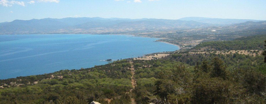
•3 THE APHRODITE TRAIL (my total time 4h01, includes short stops for drinking and photography and even a swim in the ocean; +-453m, 1 lap): This is (one alternative of) walk 20 in /Daniel/ and is also walk 1 in /Goetz/. I also added a part of walk 19 in /Daniel/ (walk 3 in /Goetz/) to get to/from a nearby beach. To get to the trailhead take the Nea Amoroza minibus from the Karavella parking in Ktima to Polis. There switch to the corresponding Polis to Baths of Aphrodite minibus. Reverse procedure on return. This is one of the most beautiful walks on the entire island.
You will not even need a guide book or map (it might even be best without…), as the whole path is very well marked. Follow the small yellow marker signs (and any other bigger signs you see reading “Nature Trail” or “Aphrodite’s Path”). Both guides above seem to have at least slightly different ideas at points close to the start (but not the Rough Guide, which also describes this walk). Instead just FOLLOW THE MARKED TRAIL.
Approaching the end of the walk, when you are almost touching the coastal track used in walk 19 in /Daniel/, take a switchback path down and head for the sea. When you after a few hundred meters are close to the first beach you can cross a field to your right on some jeep tracks and descend a short eroded path on the other side. Be sure to pick up the switchback path again on your way back, the track is not too interesting. Use the upper path/remains of older tracks and do not descend to the track again before you are forced to when you are fairly close to the Baths.
•4 POLIS – LATCHI – NEOHORIO – ANDROLIKOU – PRODROMI – POLIS (my total time 4h57, includes short stops for drinking and photography; +-422m, 1 lap): This is walk 1 followed by 2A and 10 in /Chilton/. Take the Nea Amoroza minibus from the Karavella parking in Ktima to/from Polis. A walk with focus on agriculture and goat farming. Unfortunately most of the former unpaved roads and tracks are now under asphalt or concrete.
No big navigational problems en route. At the start I could not see the “Popular Bank” (some new development in progress), but the mentioned café, travel agency and supermarket were all there so directions were easily confirmed. After the goat farm just out of Neohorio directions are a bit more strange. As the road dips down into the first prominent valley there is absolutely no crossroads worth mentioning. After that the road winds on for a long time. Just starting to ascend from the SECOND prominent valley there IS a major crossroads. Keep left (straight) here, more or less on the level, and you will after another long stretch start to descend into the mentioned gorge, which is the THIRD prominent valley.
•5 AYIOS NEOPHYTOS – MELISSOVOUNOS – KOILI – AYIOS NEOPHYTOS (my total time 1h50, includes short stops for drinking and photography; +-249m, 1 lap): This is walk 11 in /Daniel/. Take the Alepa bus number 4 (the Empa/Tala bus) from Karavella to Ayios Neophytos. Return on the same bus. Note: Not all number 4 buses goes all the way to the monastery. Suggested bus times: 0930 form Karavella, return on the 1230. Obs: The bus can be as much as ten minutes early on the return, and beware that the 1230 is actually the LAST returning bus from the monastery. If these times do not suit you, you can walk the 2 kms up/down the road from/to Tala village for more buses. This walk has tremendous views of the Paphos area.
No big navigational problems en route. Note that the 15 min point has several tracks going uphill. The one REALLY going uphill is a shortcut (overgrown eventually) that demands some endurance. You can also skirt the entire olive grove and just follow the main track.
The decent to the monastery is not too overgrown (at least not in autumn) for the use of shorts.
•6 LARNACA SALT LAKE (my total time 4h14; 259a 241d; net walking time 3h16): Just use the Larnaca tourist map or similar. Walk south on the Larnaca beach promenade and cross over to the Salt Lake Park on the Agias Phaneromenis street. Once on the official trail you can walk around the entire lake if you want, e.g in a counter-clockwise fashion (I believe it is easier to find your way in this direction). Where the path ends you can connect to the other side strolling on the fairly wide sidewalk on the main road.
In season (summer I guess) there will thousands and thousands of birds on the lake, even flamingos. Myself (December) I encountered mostly dogs (and luckily also their owners…), but one serious warning: DOGSHIT ALERT!!!
•7 AGIA NAPA – 93M – AGIA NAPA (my total time 3h31; 311a 289d; net walking time 3h04): This is an expanded version of walk 29 Short Walk in /Daniel/. Walk to the 93m high hill before Cape Greco, then head for the main road and walk (at least partly) the bicycle path back.
•8 AGIA NAPA – PROFITIS ILIAS (my total time 2h26; 291a 230d; net walking time 1h40): This is walk 30 in /Daniel/. The book is really bad here, stick to the signposted E4 as much as possible instead of venturing into overgrown or nonexistent side paths. Not well updated either, I do not know if the last stretch towards Profitis Ilias is even possible, this part is obliterated by a new main road. I just strolled down into Protaras and ascended to the church from there.
•9 LARNACA PROMENADE (my total time 1h38; 62a 59d; net walking time 1h23): Want to see how far south you can get just walking the promenade (and connecting sidewalks)? In fact you can continue until the airport fence blocks even the coastline. Plenty of possibilities for refreshments under way.
• Good starting points: • Platres – nice village in the mountains • Troodos – the village in the middle of the action • Paphos – buses will take you around to walks in the Akamas area (see below for more info) • Larnaca – good bus connections, some local walks
• How to get there: • By air
• More info: Sorry, none yet
This page was last modified at March 6, 2026.
©2002-2026