Λέσβος – North-East Aegean
In terms of sheer quantity most of Lesvos should be an island walkers dream come true, as it probably has the largest number of easily accessible walks in the entire Aegean. It may have little to offer serious trekkers or mountaineers, but for normal walkers it has an immense number of opportunities. During my stay some newly expanded tracks (mainly in the Agiassos area) caused problems for me, but the written sources should now be updated to reflect these changes.
For eating and drinking Lesvos is mostly a pleasure. Many good and/or interesting Tavernas and restaurants all over the place. Very good (white) wine from the nearby island of Limnos is readily available, and the most usual brands of Retsina are also good. “Malamatina” is the one I liked best on this trip, and this can be found everywhere. Later I have learned to appreciate “Georgiadi” perhaps even more! This is also easily available. It is more difficult to find good (or even drinkable…) reds. I was told that even the Limnos reds were not that interesting, so I stuck with the (excellent) whites. My personal favorite restaurants were: In Petra, the taverna of the “Agrototuristikos Sineterismos Ginaikon Petras” (Petra Women’s Agricultural Tourism Collective) and “O Rigas”. For fish two other very good ones were “I Gorgona” (The Mermaid) and the other fish taverna next door (I think the name was “Christos”). Lonely Planet recommends “To Tyhero Petalo”, but I would have left that one out. Tasteless Taramosalata, dry Moussaka and ruined red wine (Yes, I tried to get a good one) vouched for the only bad experience on this island. In Mitilini, “Kalderimi” and “Lemoni kai Prasino Piperi” were fantastic. Another (simple) one I really liked was the “Averof”. Lonely Planet also recommends “Stratos”, but you do pay premium prices here for not necessarily premium fish (i.e not really fresh).
For staying in a noisy town like Mitilini you should select a very good hotel, and I just cannot praise the “Hotel Lesvion” enough.
Walks below are divided in three sections, one for those staying in the Anaxos/Petra/Mithimna area, one for walks accessible from Mitilini and one for walks from Agiassos. Even the walks from Agiassos can technically be done as daytrips from Mitilini by bus, as I did, dividing my time with one week in Petra and one week in Mitilini for contrast.
Selected walks from Petra: For walks in the Petra/Mithimna area take a look in “On Foot in North Lesvos” by Mike Maunder (referred to below as “/Maunder/”). For walks in the Anaxos/Petra area take a look in “Walks in North Lesvos” by Lance Chilton (referred to below as “/Chilton/”). There is also a few walks in “Landscapes of Lesvos” by Brian and Eileen Anderson (referred to below as “/Anderson/”). For treks in the area, see “Trekking in Greece” by Marc Dubin (referred to below as “/Dubin/”), but the descriptions in this out-of-print book are mostly outdated now.
UPDATE: Hopefully the 2nd edition of /Anderson/ is updated to make my objections below unnecessary.
•1 PETRA – LAFIONAS – AGIOS ALEXANDROS – LAFIONAS – PETRA (my total time 4h40, includes short stops for photography, a small breakfast and lots of “research”; +-526m, 2 laps): This is walk 23 (Longer walk) in /Anderson/. You can also see it as walks 20 + 22 + 19 (but in reverse) in /Maunder/. The second part of the walk is walk 12 in /Chilton/. The third part of the walk is also listed under walk 12 in /Chilton/, as an alternative return. By the way, when /Anderson/ and the other books start many walks at the “square” in Petra, they mean the taverna-filled area by the quay, not the only real square (which is on the other side of Petra Hotel).
A good walk, but had more than its fair share of problems under way.
This walk had a difficult start as there was an unfortunate misprint in /Anderson/. “In five minutes as the road bends right, fork left”. This should read “In less than a minute (50 meters)…”. I think I must have wasted three-quarters of an hour after this trying to find the correct track up towards Lafionas, after getting to the by-pass road by walking the second (as it turned out…) stream bed… The first one is actually just a small ditch beside the narrow road. The map/sketch in /Chilton/ gives an excellent graphical depiction of this and all the main tracks and paths found around Petra. /Maunder/ has a correct textual description, only a slightly different route the first couple of hundred meters, unfortunately I did not have that book at the time.
Starting “Alexander’s Circuit” also proved difficult due to my interpretation of the text on page 110 in /Anderson/. My interpretation was (after passing the initial taverna) that there were THREE junctions: 1 – Go Left in T-Junction, 2 – Follow Sign, 3 – Go Right in T-Junction. This however turned out to be wrong, as the (first) signed junction are in fact the second T-junction mentioned in the text, so there are only TWO junctions this far. I also doubt you willactually see other signs than this one inside the village, there is another one hidden in canopy where you a little bit later turn left uphill, but you can hardly see that one from below, only when you are on your way back down… Keep this in mind and you should find your way.
Or, /Chilton/ has a more detailed description of the streets in Lafionas, you might be luckier with that one. However, the (somewhat) signposted route described in both /Anderson/ and /Chilton/ is not the best way to go. My (mis-)interpretation of the text in /Anderson/ led me to find a much more interesting route! Only /Maunder/ has got this right. Again, unfortunately I did not have that book just yet. There is in fact a fairly well hidden Kalderimi (or remains of one) for the first part of the circuit, making walking up the concrete road unnecessary. There are waymarks for this option also, but (as mentioned) the signposted route (if you can spot it) goes up the road.
 •2 PETRA – ANAXOS – AMBELIA (my total time 1h38, includes short stops for photography; +54m -60m, 0 laps): This is walk 24 + first half of 25 in /Maunder/. Portions of the first part of the walk is also described in /Chilton/ under walk 1 (Petra to Anaxos), but with a slightly different approach. The second part of the walk is approximately the return part of walk 2 in /Chilton/ (but in reverse).
Nice walk to the beach(es). No big problems en route, but I could not see the “small path up and over the rocks” towards Anaxos mentioned by /Maunder/. Rounding the cliff by stepping from stone to stone so that I did NOT get my feet wet was a bit awkward, but not too difficult. /Chilton/ has a different approach here, you might also try that one.
•3 AMBELIA – ANAXOS – PETRA (my total time 1h51, includes short stops for photography; +106m -98m, 1 lap): This is second half of walk 25 in /Maunder/ + walk 1 in /Chilton/. The first part of the walk is also described under walk 2 in /Chilton/ (but in reverse).
Easy stroll home from the beach. No problems.
•4 PETRA – PETRI – MITHIMNA (my total time 3h42, includes short stops for photography, small breakfast; +361m -338m, 2 laps): This is the first part of walk 20 in /Anderson/. Approximately the same as walk 9 + 10 in /Chilton/, and approximately the same as walk 14 + 13 (but in reverse) in /Maunder/.
A great and exhilarating walk, one of the best on the island.
I would only like to add that there is a sign-posted diversion on a nice footpath for the very last leg towards Mithimna. It means you will go around on the lower side of the wooded park/picnic area outside Mithimna instead of on the upper side by the sports ground. Recommended.
•5 MITHIMNA – PETRA (my total time 1h31, includes short stops for photography; +102m -126m, 1 lap): This is the second part of walk 20 in /Anderson/. Or you can use /Maunder/ where it is walk 7. It is also walk 10 in /Chilton/, but in reverse.
Easy stroll home from Mithimna. No Problems.
I did not use the route suggested in /Anderson/ for the last couple of hundred meters, there is no need to do any walking along the main road when you approach Petra, just cross the road and take the track on the other side, towards the football pitch. See e.g /Maunder/.
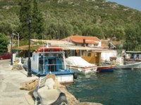
•6 PETRA – ANAXOS – MEGALI TSIHRANTA – AMBELIA – ANAXOS – PETRA (my total time 5h48, includes short stops for photography, short breakfast and a swim; +-338m, 2 laps): This is walk 1 (in reverse) + walk 3 + walk 2 (approximately, first half, actually /Maunder/ 25 as in my walk 3 above, but this time in reverse) + walk 1 in /Chilton/. I expanded the basic walk with a trip to farm (picture right) on the headland after the (first) beach.
Parts of this walk is just transport, other parts are nice and interesting. The main beach for this walk however was a disappointment. Just two people there, but it was uncomfortably stony and the water was cold even in late September.
No real difficulties, except /Chilton/ does need updating now. The first gate encountered towards Megali Tsihranta was laying smashed on the ground, the second one was missing. The path down to the beach was gone, the track going to the “building on the right” had been expanded and went all the way down.
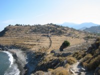
•7 PETRA – PETRI – ROUSA – STIPSI – PETRA (my total time 5h54, includes short stops for photography and a short breakfast and another short snack break and some sightseeing in Stipsi; +-722m, 1 lap): This is walk 14 (I actually used the same route as in my walk 4 above, from /Anderson/ 20) + walk 16 in /Maunder/. Returned by strolling back down on the road. There is very little traffic here.
However, the peak point described in /Maunder/ is a minor one, the real “Rousa” is a couple of hundred meters behind, to the north-east. A concrete peg marks the top (picture left). Just curve back above the main Antenna on the mountain (no need to go ahead to the “gated animal pen”) using what you can find of animal tracks. Then go through a gate in the stone wall on your right. After that it is just to aim for the top (or the concrete peg if you can spot it), keeping the wall fairly close on your left where the animal tracks are easiest for walking. Great view, if it is not too much fog or haze in the air.
•8 VALLEY OF THE MILLS (my total time 4h06, includes short stops for photography, a short breakfast and some “research”; +-346m, 1 lap): This is (part of) walk 12 in /Maunder/. I did the walk as described until the really tough part begins, where the path ends and there is only the river bed going further. Then I returned the same way.
The route up the valley was sometimes difficult to find as there was a myriad of sidepaths. The main route is marked by blue paint blobs, but the marking may not be visible at crucial points. For the first time using this booklet I found the text difficult to interpret and I was never quite sure where I was compared to the descriptions. However, it is really just to follow the marked trail until it ends.
One point should be made specifically though: At the “concrete cistern (10 mins)”, fork LEFT.
Selected walks from Mitilini: For walks close to Mitilini take a look in “Landscapes of Lesvos” by Brian and Eileen Anderson (referred to below as “/Anderson/”). These walks (except the city walk, of course) use the Mitilini local bus to get to/from trailheads. The buses leave from the north of the harbor, where there is a ticket kiosk, NOT where indicated in /Anderson/, that is just a bus depot. Remember to buy two tickets per person so you have one for the ride home. For some weird reason tickets are NOT sold on the bus!!!???
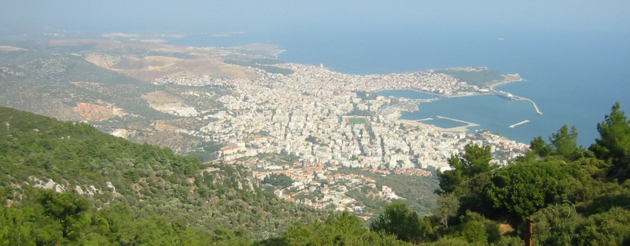
•9 LOUTRA – PROFITIS ILIAS – LOUTRA (my total time 3h13, includes short stops for photography and a short breakfast; +-498m, 1 lap): This is walk 1 in /Anderson/.
A very nice walk with lots of great views, the best view of all over Mitilini (see top picture). No problems en route.
 •10 LOUTRA – KOUNDOUROUDIA (my total time 1h00, includes short stops for photography; +68m -113m, 1 lap): This is walk 2 (Short walk) in /Anderson/.
A nice stroll. No problems en route, but do take the LEFTMOST fork off the main road near the start of the walk (11mins).
•11 THERMI – PANAGIA – THERMI (my total time 1h58, includes short stops for photography; +-111m, 1 lap): This is walk 3 in /Anderson/.
Another nice and also very interesting stroll.
Entering Loutropoli on the return I could not get a match with the streets/text/map and just continued to stroll straight into town. Probably my fault, but the use of “Upper” and “Lower” Thermi is weird when it is really Loutropoli they are talking about the whole time. If you read the text as “Upper” and “Lower” Loutropoli it does make sense. So don’t hesitate to fork left up a track/gravel road just before you enter this town.
•12 MITILINI CITY WALK (my total time 2h20, includes time for photography and sightseeing at the kastro, but NOT visiting museums; +-89m, 1 lap): This is the “Walking tour around Mytilene” in /Anderson/, page 37.
Leave this walk as an early Sunday stroll, traffic is deadly at all other times.
Selected walks from Agiassos: For walks close to Agiassos take a look in “Landscapes of Lesvos” by Brian and Eileen Anderson (referred to below as “/Anderson/”). This town and surroundings promises the best walks on the island, but summer 2004 a lot of bulldozing took place, and when I arrived in late September there were many fresh bulldozer tracks. Unfortunately I seemed to be able to pick just those walks that was affected by this… I did these walks as daytrips from Mitilini, but the town is a nice place to stay also. This is what people who have stayed has reported: “We thought that it was a great place to stay – very Greek. We stayed five nights and, I am pretty certain, we were the only foreigners there. The souvenir shops are not really aimed at foreign tourists, but at locals for whom the town is something of a religious pilgrimage destination. There are some nice rooms there. These are at the top of the town just at the start of the road to the Sanatorium (22520 22902) – not to be confused with some rather dirty and expensive ones at the bottom of the town by the bus stop.”
UPDATE: Hopefully the 2nd edition of /Anderson/ is updated to make my objections below unnecessary.
•13 AGIASSOS – MOUNT OLYMPOS – AGIASSOS (my total time 3h19, includes short stops for photography and a short snack break at the top; +569m -502m, 1 lap): This is walk 8 in /Anderson/. My timing of the return ends at the initial 12min point.
This is a “top” walk of course and undamaged from any more recent destruction.
Just a few notes: The “water tank” is not dated 1985, but 1995. After that one I would suggest you stay on the marked path at all times, not diverting into any minor paths as suggested in the book. There are paths all over the place and very difficult to now what is what. Just after the “large white garage-like building”, when the road has bent left, there is in fact a surviving Kalderimi to the top. Look for waymarking high up on the bank of the road on your right. I did not see this on approach and did not do it, so I do not know if it is safe. It looked VERY narrow and steep after the initial stretch.
•14 AGIASSOS WOODLAND CIRCUIT (my total time 1h23, includes lot of “research”; +206m -273m, 1 lap): This is walk 7 (Shorter walk 1) in /Anderson/. My timing starts at the 12min point.
This reportedly very beautiful woodland stroll is now for the most part destroyed by bulldozers and it is difficult to find the returning path. If you are going to try anything from walk 7 in /Anderson/ you should try the “Shorter walk 2”. At the the start of that one is very nice, climbing past several nice churches.
If you insist on doing THIS part of the walk make the U-turn over the valley floor shortly after the 22min point (on the bulldozed track) and hunt out the returning path crossing the stream bed some minutes later on your left (shortly after an area of water seepage). It is not VERY easy to spot, and since it has not been used at lot this summer it is narrow and overgrown. Keep left at a fork. Eventually you will reach the Kalderimi that now should be used as the start of the main walk. Turn left to return to town.
•15 AGIASSOS – KARINI – ??? – AGIASSOS (my total time 4h57, but this is not very relevant, as I could not complete the walk; +-590m, 3 laps): This was intended as walk 5 in /Anderson/, but now large parts of it has been bulldozed to pieces.
The Kalderimi to Karini is very nice. Shortly before the “old bridge” after Karini destructions start, and I was not able to find the right track or path to follow. Running out of time I walked the freakin’ road all the way back to town (by using the track that cuts over the path and goes up to the road, see the map).
The only useful walk left from this now is Agiassos – Karini (- Agiassos). It is possible that the Agiassos – Ag. Dimitrious – Agiassos leg may have survived, I had no time for more research in this area, and was far too fed up at this point to go back for another day.
A sad ending of something that could have been truly great, and a sad development for Brian and Eileen Anderson and their very good book. It is as if the bulldozers were just waiting for Sunflower to publish it.
OBS: After my visit, updates were published very fast, many thanks to Sunflower for this. As always, be sure to get the latest edition before you travel, including any Update Sheets you can find on their web site!
• Good starting points: • Anaxos • Petra • Mithimna (Molyvos) • Mitilini • Agiassos
• How to get there: • By air • By ferry from some other North-East Aegean islands • By ferry from the mainland • By hydrofoil from some other North-East Aegean islands
• More info: Sorry, none yet
This page was last modified at February 23, 2026.
©2004-2026 .