CORSE – France
Corsica is one of the islands that has most to offer the truly experienced (or even expert) walker. It’s long-distance trails are many, and this is well known for at least all French trekkers. The whole island is just covered with mountains, some of which can even regain patches of snow for the entire year. But despite of this, also easier walks can be found, some of which e.g let you savor truly great coastal scenery.
One of the most well known treks on Corsica is the GR20. It slashes through the island from north-west to south-east. Whatever you do on the island, try to at least do some small part(s) of it. There are also several “Mare a Mare” (Nord, Centre and Sud) and “Mare a Monti” (Nord and Sud) trails, which are somewhat easier. All these trails have very good waymarking, and many shorter walks in the hills and mountains might coincide with one or more of these routes, making finding your way (for once) a sheer bliss.
It is seldom that I recommend a specific wine on my pages, but this time it must be done. If you at all drink wine, you must try the “Domaine Gentile”, which is AC Patrimonio. AC Ajaccio is also excellent I hear. And what better place to enjoy this wine, but at Ajaccio’s supposedly best restaurant “A La Funtana” (in the old town at 9 Rue Notre Dame). This elegant place, still with an almost informal air to it, offers excellent and comfortable dining, served by a friendly, polite and professional staff. Good value too, from e.g one of their 38€ menus. Another excellent place is the “Restaurant de France” (close to the upper end of the pedestrian street, at 59 rue Fesch), which has a more limited menu and a kitchen with a more limited bag of tricks, but where the food perhaps is (or can be) even better… A full meal here will set you back around 45€. And you will not even be ridiculed for not speaking French in any of these places. What a bliss. English-speaking staff can also e.g be found at l’Osteria. Decent food at that place too, and I especially remember that the starter was pure heaven.
A few words has to be said about flying to Corsica from Nice. Hopefully CCM (now Air Corsica) has a better terminal now with the opening of the new Terminal 2, but at my visit the CCM terminal was an insignificant building to the LEFT of the old Terminal 2 when facing the entrance. I really had no time for this kind of detective work at my arrival, since I was already delayed, and it was just pure luck that I actually managed to catch my flight. I also found it very weird, since there was no information about this on the Nice Airport website or in any material received together with my tickets from the travel agency. All it said was “Terminal 2”.
Selected walks: For shorter walks on Corsica take a look in Noel Rochford’s “Landscapes of Corsica”. All references below are to this book as “/Rochford/” (PLEASE NOTE: when I refer to walk numbers in this book they are taken from the 3rd edition). You should also check out “Corsica” by Klaus Wolfsperger and “Walking on Corsica” by Gillian Price.
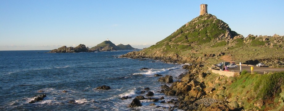
•1 POINTE DE LA PARATA – CAPIGLIOLO – D111 (my total time 3h29, including breakfast and short stops for photography; +-341m, 2 laps): This is another variant of Walk 1 (Alternative Walk) in Rochford. I added the Tour the la Parata (Short Walk 1) and the end of Short Walk 2 at Pointe de la Corba (nice place for a picnic). I excluded the Anse de Minaccia because of high tide and heavy waves coming in, wading would have been necessary to get up from the Plage de St-Antoine beach and over the headland to the next beach.
Pointe de la Parata is served by city bus line number 5 from Place de Gaulle in Ajaccio. At least in winter this bus line terminates one stop short of the Pointe, where /Rochford/ indicates (another) car park (this is also the “700m” point mentioned), and you will have to start the walk from there towards the tower. The line 5 bus terminus at Place de Gaulle is one street west of the square itself, i.e just after the Diamante shopping center. One funny thing about this particular bus route (it does not even apply to the airport bus, line 8, run by the same company) is that you will have to pay a baggage “supplement” even if you just carry a daypack. Just in case you wonder why the driver will give you TWO tickets for a single trip…
/Rochford/ recommends just “light shoes” for this walk, but I cannot subscribe to that opinion, waterproof boots are at least much to prefer after rainfall, and when the tide is in and the waves are big (see comments about Anse de Minaccia above).
The addition of the Tour the la Parata (big picture above) is greatly recommended, but an early start is best. The 8 o’clock bus at latest, if you are to just beat the first tourist buses. Also, in winter (after October 1st), there are not as many buses as described in Timetable 1 in /Rochford/. After the 8 o’clock (or 8.05 to be precise), there is not another bus until 12.05. The relevant returning buses are (from the bus terminus) at 12.30, 13.30 and 14.30 (passes the D111b crossroads 3-4 minutes later). On Sunday the departures are even fewer.
The walk itself is very easy to find and follow, as it is also waymarked. There are a few forks, but the going is pretty obvious. Great coastal landscapes are encountered all the way. Just before Capigliolo I could not see any steps by the wall (not that I looked for them either), I followed the waymarking, which turns right onto the earthen track. Then (shortly) it’s left for the beach.
•2 PONTE DI NOCETA (my total time 5h42, includes one longer picnic, some investigation and short stops for photography; +-724m, 3 laps): This is Walk 6 in Rochford. Great train ride to Venaco. The walk itself is mostly easy to follow, but a few missing signs and slightly insufficient directions in /Rochford/ can cause small problems. There was also a small problem in finding where the walk actually started, below Lugo. No sign or waymarking where it should have been. I mistook the arrows in the street for waymarks, and that only brought me up to the main road. “Downhill to the right” must be taken quite literally, then. You are soon at the wooden cross, but the sign was missing at my visit. There was one up at the main road, though, and there was another at the fork where the real ascent begins.
On top of the hill, the path dissolves and the last waymark is just before a newly fenced off area. Just follow the fence to the right and find a spot where it is very easy to climb down to the road. No signs or waymarks here anymore. At the transmitter station the road forks, take the left fork. A waymark a few meters ahead confirms this.
2 kms later, “ON a sharp bend to the left” is actually 20-30 meters AFTER the bend. Orange marks here. There is some goat tracks to the right on the bend itself, but these are steep and overgrown. You must take care to find the marked path here.
After you have rejoined the road the SECOND time (take care to follow the right fork at the ridge just before, the path divides up a lot up there, among sheep dwellings, a small but unnecessary detour will follow if you go straight and to the left, careful study of the map needed) a third waymarked shortcut of the road not mentioned in the book will drop you right down to Zucchero, where you must find the waymarks for a path on your right. All signs where torn down at this point, pieces left on the ground.
Just before the D43, the path is obliterated by a new bulldozed track. Just follow the track for this short stretch. After Ponte di Noceta long portions of the “Mare a Mare” back towards Venaco has been badly damaged by the digging of a trench in the middle (!) of it, carrying water (?) pipes.
On Sunday the Venaco train station is closed (“Gare Fermé”), so if you have not bought a return ticket, make sure you enter the train in front so you can buy a ticket from “le Conducteur”. Also be aware that many of the smaller train stations are even permanently closed, and the train only stops on demand. Full details can be had in the “Horaires” (timetable) obtained e.g. at the Ajaccio station.
•3 GR20 FROM VIZZAVONA TO ANCIEN REFUGE DU CAF (AND RETURN) (my total time 6h03, includes several short picnics and lots of time for photography; +-656m, 1 lap): This is Walk 4 in Rochford (Access by train version). Fantastic walk with immense views. Greatly recommended. Pretty easy to follow, the waymarking is excellent. Not too difficult either, but very steep in sections. The ultimate in footwear is recommended. You will need superb ankle support and excellent grip!
There is just one point in the woods at the approach to the “bridge over the Agnone” (well, actually there are more bridges earlier on, but…), following the Sentier des Cascades, that the path might sneak off unsuspectedly to the right. So stay concentrated. Coming in the other direction there is no problem.
At other points, higher up in the valley, there is hardly a path at all, but the orange paint blobs are frequent. You should always try to stay in sight of at least one of them.
•4 MARE E MONTI NORD* FROM EVISA TO OTA (GORGES DE SPELUNCA) (my total time 3h13, including breakfast and time for photography; +188m, -671m, 1 lap): This is Walk 10 in Rochford. Not actually a gorge walk, the path is always in the hill or mountain side, but as such very easy to follow, there is nowhere else to go. Waymarking is also excellent.
In the winter at least, the only “bus” to Evisa is at 7.45 in the morning. You do not need to buy a ticket in advance, pay directly to the driver. But do check departure times at the information booth(s) inside the Gare Routiére, also for your returning bus from Ota. The Evisa bus leaves from just outside the main entrance of this building. In low season a maxi-taxi is used, you will share its space with countless boxes going to some post office or another, and maybe the drivers dog, but not a lot of other passengers.
The initial instructions to find the path in Evisa was a little confusing (although the sign was HUGE, once spotted). There are actually several enclosed parts of the cemetery, and even an entryway between them. What the book means is the LAST of the enclosures. After the enclosures there will just be a fence. Continue until you can read the sign on the LEFT of the road, pointing to the right.
Don’t forget the last bus back from Ota at 14.00. There are possibly more departures in high season.
A few things must be said about the coastal road back, from Porto to Cargése. This is an old and narrow road, with NO tunnels. With a very indented coastline, now this will make the need for a curve or two… Actually I think it must be close to a world record! Do have your life insurance in order if you are ever going to drive here yourself.
*) Also coincides with the Mare a Mare Nord here
• Good starting points: • Ajaccio – at least a weeks worth of walks not too far away • Several other places to start off a walking holiday, e.g Calvi, Corte, Bastia, Porto Vecchio…
• How to get there: • By air • By ferry
• More info: Sorry, none yet
This page was last modified at March 6, 2026.
©2002-2026 .