Τήνος – Cyclades
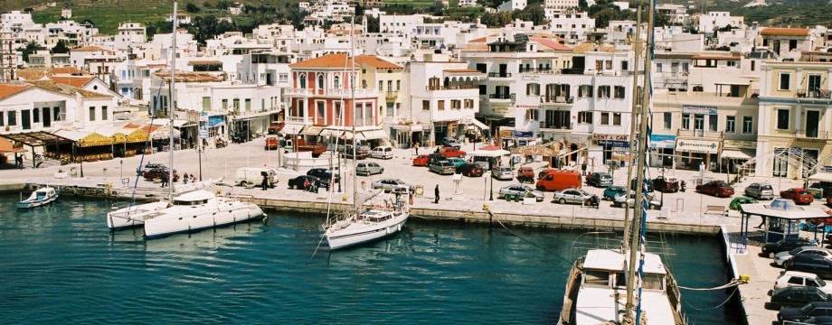
The sacred island of Tinos can be considered the religious center of Greece. As such it receives a lot of Greek tourists (or pilgrims, which is the ancient term), but not a lot of foreigners. Just beware that there are some holidays through the year when the island will be filled to more than its bursting point. On the other hand it might be an interesting spectacle… For the rest of the year accommodation is plentiful. Tavernas tend to be simple but adequate.
A visit to the church of Panagia Evangelistra with the famous icon is of course obligatory. This is the stuff that all the fuss is about, and to which also 500m of street is devoted in the form of souvenir shops…
A hilly, but very cultivated landscape makes walks beautiful, but not necessarily very strenuous. The island is also known for its many dovecotes, and you will see lots of those when you are out walking.
Selected walks: For walks on Tinos take a look in “Walking the Aegean Islands” by Dieter Graf (referred to below as “/Graf/”) or his newer “Amorgos, Naxos, Paros and the Eastern & Northern Cyclades”, which should be more up-to-date. On the web visit Walking, hiking and trekking on TINOS by Raymond Verdoolaege.
•1 Moni Kehrovouni – Karya – Exobourgo – Kumaros – Loytra – Kampos – Hatsirados – Ktikados – Hora (4h12 walking time, includes the ascent of the Kastro at Exobourgo, which for some reason is not included in the walking time quoted in /Graf/, but do add time for sightseeing at the Monastery, e.g lunch at Drosia etc.): This is walk 48 in /Graf/. A beautiful and very varied walk, which at some points is a bit difficult to find and follow, just read the text carefully, as well as examining the map, and you will probably find your way.
UPDATE: The route up to Exobourgo has been changed to a different one in the newer book, so my notes up to that point is now of little use and is left just for the sake of completeness (2010):
After the 0’08 point you are supposed to pass a fence, and yes on the other side of the fence were a more prominent path to be found, between walls. What the text does not say is WHERE you are supposed to cross over, and the fence is actually on top of the wall, which makes the whole thing a bit nasty. I have no good answer myself, I did not take the time to investigate. If someone does not repair the damage soon, you may possibly make the leap where some meters of the fence are dragged down to the other side of the wall, perhaps with pieces of my red sweater on…
Shortly after at the dovecote and chapel you bear RIGHT/STRAIGHT on a dirt road (but I do admit it IS left of the chapel, but I find the instructions vague here). At the next chapel the way heads right, yes, but I would call it ABOVE the chapel, since you are in fact above it in the valley (although you do come slightly from below at this particular point, but again very vague instructions). Following the curving wall will eventually get you down to the main road just inside the town limit of Karya (see road sign on your left). Turn right along the road and curve left around the big church, immediately after is the steep concrete road up right. There are at least three churches above the village, and it is not easy to know which one Dieter is talking about here. When the concrete stops (or rather, enters a “Private” area) a cobbled path continues. If I remember correctly you pass at least one church, and eventually you will find a church with a couple of tables and chairs and indeed, a path crossing some fields. The path becomes increasingly overgrown, better take to the fields on your right and head for the road this way. You will have to climb a couple of walls, though.
At Exobourgo the path to the top is sign-posted. By all means go for it, but the wind on the top can be insane… Back down towards the signpost, turn left on the road. In a right turn of the road there are TWO paths forking left, you take the LEFTMOST path going steeply downward.
Just before Loytra, look carefully at the map, the way is down right into the town only after you have walked a few meters LEFT on the main road, which you cross here.
As you approach Kampos, there are many forks, use your best judgment, you are NOT supposed to enter the town, bear a LITTLE to the left.
The instructions guiding you through Hatsirados are just hopeless. When you enter the town from above by the most prominent lane, turn sharp left up some stairs just before the bottom of the valley. Before the turning point there is another chapel in front of you to the right. Soon you are at the car park, but there are no steps leading down from there! Just take the road for an additional 100m towards Ktikados.
At the extremely nice village of Ktikados, the tavern Drosia is not exactly open for lunch, but the friendly woman in charge will probably be able to fix you a salad, at least…
From the tavern it’s NOT down right, it’s UP right and THEN curving down right. Do NOT descend much towards Ag. Maria, the way goes straight ahead, and crosses the valley high up. There are at least one fork right steeply down in the valley, but this is not the correct route.
• Good starting points: • Hora – buses to most destinations on the island, and some walks can be done right out of town
• How to get there: • Frequent ferries from other islands in the Cyclades North • Some ferries from islands in the Cyclades Central (Paros, at least) • Frequent ferries from the mainland (Rafina)
• More info: Sorry, none yet
This page was last modified at March 1, 2026.
©2001-2026 .