Μήλος – Cyclades
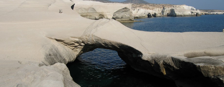
Milos is a really terrific island. Its volcanic landscapes are varied and beautiful in its very own way. However, scarred by mining, as the islanders are selling off their island by the truckload. It also has a really incredible coastline in places.
Except for the port of Adámas, Milos is a fairly quiet island, but it is definitively alive. The waterfront of the former noisy, dusty and sunbaked Adámas has been totally reworked and today stands out in its glorious new appearance. It is also excellent for sampling some sea food. You must for instance taste the local sardines (“Gavros”). Be aware that the overly popular tavernas at the waterfront can have horrible service. They just cannot cope with the crowds. Much more pleasant are the tavernas a couple of hundred meters east along the coast road, try for instance the restaurant “O ZABBAS”.
Many hotels in the port are located along the noisy Pláka road. For a quiet location, instead go left from the harbour to a hotel backed beach. Hotel Delfini for instance is old-fashioned and cosy.
For walking Milos is also very interesting. Both great landscapes and things of historical interest to see all over the place.
Selected walks: For walks on Milos take a look in “Walking the Aegean Islands” by Dieter Graf (referred to below as “/Graf/”) or his newer “Santorini, Sifnos and the Western & Southern Cyclades”, which should be more up-to-date. On the web visit Walking, hiking and trekking on MILOS by Raymond Verdoolaege (/RV/). You should definitely go for a better map than what the guide books have to offer, and the Anavasi (1:32000) map is just that. Warmly recommended.
•1 ADÁMAS – KLÍMA – TRIPITÍ (my total time 3h11, includes stops for photography and drinking, the catacombs were closed for repairs at my visit; +415m -284m, 1 lap): This is walk 17 in /Graf/. A similar walk can be found as walk 1 in the page Walking, hiking and trekking on MILOS by Raymond Verdoolaege. I think the route followed in /Graf/ is more interesting, as well as more challenging.
Follow the text carefully and you should be able to find your way. Mind also the comments by /RV/. This walk in its entirety may not be for everyone, but the decent to Klíma is now waymarked and I found it quite OK, just be careful.
Reading the text in /Graf/ you get the impression that the path goes down to the left of the hotel Panorama. Quite to the contrary. But once you are down you should go between the hotel and the cliff edge (I missed this).
That the catacombs were closed (entrance closed off even) presented a small problem at my visit and some slight trespassing was needed. You might consider the route followed in /RV/ instead at this point.
•2 PLÁKA – KASTRO (my total time 0h13; +99m -9m, 0 laps): The stroll up to the Kastro e.g from the Archaeological Museum is surprisingly short. Follow signs. What a view!
•3 PLÁKA – TRIPITÍ – ADÁMAS (my total time 1h11, includes stops for photography and sightseeing; +71m -216m, 1 lap): You can stroll from Pláka to Adámas on a mostly dusty track (used partly by walk 1 above, and even more of it by walk 5 below). Go via the windmilled ridge of Tripití were a short path will connect you to the lower Tripití. Then follow road sign towards Klimavoúni, but turn left on thenice flagstone road (picture above) just before this village. After that it is the dusty track and you follow this all the rest of the way.
•4 ADÁMAS – SARAKÍNIKO – AG. KONSTANTINOS – FYLAKOPI (my total time 3h31, includes stops for photography, drinking and a couple of dips in the ocean; +-242m, 1 lap): This is walk 16 in /Graf/. A similar walk can be found as walk 1 by TEUN DE LAAT in the page Walking, hiking and trekking on MILOS by Raymond Verdoolaege. Missing my bus I did the walk in reverse. One must obviously be aware that the Pollónia bus actually does NOT go via the harbour bus stop, even if the timetable here says otherwise. This is Greece remember.
The best way out of the port is to follow the main bay side road a very short stretch to a small bridge. On both sides of this bridge walkways goes left. On the far side the walkway leads into an asphalt street. Take the walkway on your side that leads into an older concrete road that runs in parallel with the newer street, between trees. The concrete road get dustier and dustier until it turns into a sunken dirt track. Follow this to a messy T-junction were you go right on another dusty road. Soon you pass a strange (almost “sunken” too) farm down on your right. When you get to an asphalt road turn left, then right again at the next crossroads (right, then left will actually lead you to the same place I believe). Where a track goes left before a fence at some houses with flowery gardens use that to partly scale the ridge (or use the traces of path found on the other side of the fence), then just continue without a (good) path to connect with a grassy track that goes directly to the turn-off for Sarakíniko on the main road. This turns the 70m you have to walk on the main road according to /Graf/ into 0m!
Reversing the route by the coast is not a big problem since the idea is to follow the coastline as much as possible, and any instructions are really redundant. I am not saying that it is always extremely easy though. Try to follow the trodden path and you should find a good route through.
•5 ADÁMAS – PLÁKA – PLÁTHIENAS (my total time 1h52, includes stops for photography and drinking; +-347m, 2 laps): This is part of walk 1 in the page Walking, hiking and trekking on MILOS by Raymond Verdoolaege followed by part of walk 2, connecting via Klimavoúni and Tripití. Just after passing Klimavoúni do not turn right at the next crossroads, this will lead you to the route over the windmilled ridge used in walk 3 above. Instead follow at first the road sign in direction of Klíma (left), but then immediately right again to go via the church of Tripití, the ending point of walk 1 above. Then reverse the route from that walk (towards the catacombs). Near the amphitheater you can continue on the very nice walk 2 of /RV/.
•6 PLÁKA – (ARETÍ) – PLÁKA (my total time 0h18, includes stops for photography; +-83m, 0 laps): Mentioned in walk 2 in the page Walking, hiking and trekking on MILOS by Raymond Verdoolaege, this diversion is nice for admiring interesting flowers etc. The first overgrown stretch can be bypassed on the field to the left. But eventually the way becomes too overgrown to continue. Time is measured from the “road” sign to Aretí below Pláka.
•7 ADÁMAS – SARAKÍNIKO – MANDRÁKIA – TRIOVÁSALOS (my total time 1h59, includes stops for photography and drinking; +235m -135m, 1 lap): This is the suggested extension to walk 16 in /Graf/ made into a separate walk. Taking in more of the strange Sarakíniko coastline has my warmest recommendations. You should not need that much sense of orientation to be able to find your way. And use my instructions for walk 4 above to find the way from the port to the turn-off for Sarakíniko on the main road. In Triovásalos you can end the walk at the bus stop for the frequent Pláka – Adámas bus.
• Good starting points: • Adámas – Frequent bus to Pláka, some buses elsewhere • Pláka – Frequent bus to Adámas, and buses elsewhere may also start in this area
• How to get there: • By ferry from other islands in the Cyclades West • By ferry from some islands in the Cyclades Central • By ferry and by speedboat from the mainland • By speedboat from some Cycladic islands
• More info: • Walking, hiking and trekking on MILOS by Raymond Verdoolaege
This page was last modified at February 27, 2026.
©1997-2026 .